Fire Weather Indices in Alaskan Tundra Expected to Respond to Climate Warming: New Article

A multi-decadal analysis of fire in Alaskan tundra ecotones was completed using records from the Alaska Large Fire Database and an analysis of future fire potential was performed based on future climate scenarios and the Canadian Fire Weather Indices (FWI).  The authors analyze tundra fire potential in different tundra areas and conclude that most areas will see substantial increase in the number of high-fire-potential days in the next few decades.  This figure shows, for example, the Seward Peninsula and Southwest areas with historical (1951-2005) fire weather indices and modeled with 3 different climate projections to 2095.  Although the Seward Peninsula FWI only exceeded 20 twice in the historical record (1977 & 2005), it is projected to exceed 20 much more frequently in the  next decades.  Read the full article:  French, N. H. F., L. K. Jenkins, T. V. Loboda, M. Flannigan, R. Jandt, L. L. Bourgeau-Chavez, and M. Whitley, 2015: Fire in arctic tundra of Alaska: past fire activity, future fire potential, and significance for land management and ecology. Int. J. Wildland Fire, http://dx.doi.org/10.1071/WF14167.

Historical and projected Fire Weather Index values over Seward Peninsula, from French et al. 2015. Black represents modeled historical FWI and colors represent modeled future FWI for the three IPCC RCPs evaluated.

Historical and projected Fire Weather Index values over Seward Peninsula, from French et al. 2015. Black represents modeled historical FWI  (to 2005) and colors represent modeled future FWI for the three IPCC RCPs evaluated.

Modeling Alaska Fire Growth Potential

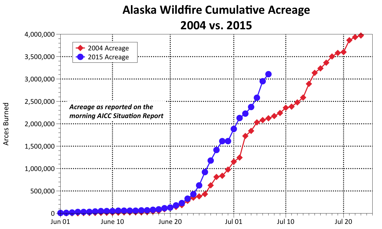
Here in interior Alaska a lot of us have been thinking about the potential for fire growth lately: as in how big could these fires actually get in 2015?  The graph below (thanks to Rick Thoman from the Alaska Climate Center-UAF for tracking this data) shows how the cumulative acres burned compares with the Season-of-Never-Ending-Smoke 2004.  As you can see, we’re well on our way to a new record year, barring a significant turn of weather patterns.  It just so happens a very interesting presentation on modeling fire growth was presented to the May 2015 American Meterological Society Conference and that paper is now available and posted on the Alaska Fire Science Consortium website: MODELING FIRE GROWTH POTENTIAL BY EMPHASIZING SIGNIFICANT GROWTH EVENTS:CHARACTERIZING A CLIMATOLOGY OF FIRE GROWTH DAYS IN ALASKA’S BOREAL FOREST by Robert Ziel, Jane Wolken, Tom St. Clair, and Marsha Henderson.

The authors show that MODIS hotspot data can be used as fire growth data to evaluate multi-day fire growth models such as FS-Pro since 97% of MODIS hotspot data correlated with final fire perimeters.  Predicting fire growth potential based on thresholds for weather and fuel moisture conditions required a climatological analysis of the conditions occurring throughout the interior Boreal ecoregion, and an analysis was conducted on the conditional frequency of the fire events (represented by MODIS detects) that occur under the range of weather and fuel moisture conditions found in the climatology.

7-6-15-Thoman-graph

Alaska WFDSS Training for FMOs and Agency Administrators

Watch how-to videos on completing different parts of the WFDSS process on your incident

Watch how-to videos on completing different parts of the WFDSS process on your incident

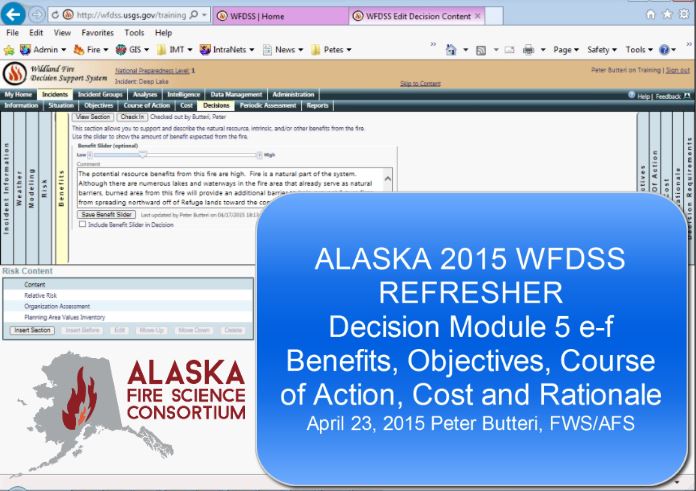
Training modules on using the Wildland Fire Decision Support System (WFFDSS) in Alaska are now available on the AFSC website.  Find a video, from 5 to 30 minutes long, on the section you’re interested in or download a step-by-step annotated Powerpoint taking you all the way from Login to Publishing a decision.

What is the moisture content of standing dead grass?

Blackline WR4-TXrange2007-crop

April 2007 burning standing dead grass on Texas Range near Delta using a terra-torch (BLM-AFS).

Eric Miller, BLM Alaska Fire Service Fire Ecologist, assists with a lot of prescribed burns on military training ranges in Alaska where the primary fuel is standing dead grass (photo) and this question was often on his mind. He found that existing fine dead fuel moisture tables underestimated the moisture content in dead grass. Six years and 74 prescribed burn days later he had collected 409 grass samples and 285 weather observations, enough to build several empirical- and process-based fuel moisture models. He gave a presentation on his findings at the Alaska Fire Science workshop in April 2015 and prepared a 1-page research brief on the highlights of his study.

Eric introduced a simple “Rule of Thumb” for predicting dead grass moisture content in the field:  MC = rH/5 + 4   You can find the new fuel moisture and ignition probability calculators based on Eric’s field campaign, along with other useful tools like a dead grass fuel loading photoseries and CFFDRS calculator, on his website:   http://www.taigafire.org/

EAM-RB-2015

AFSC workshop and open house on Wednesday, April 1

2151fe7930311233d3077020db3780aa_f39292015 Spring Alaska Fire Science Workshop

Wed, April 1
Wedgewood Resort Garden Room
Open House 9:30 am – 1:00 pm

Presentations 1:00 – 5:00 pm
This is a busy week for fire managers, with IMT, FMO, AA meetings, plus M581 training and the dispatch workshop! Stop by our Open House Wednesday morning for a quick cup of coffee and tell AFSC about your science needs, check out a poster, or grab a new research brief. We’ll have presentations on research relevant to your work starting at 1 pm Wednesday afternoon, including Devon Barnes sharing his results on sprinkler use for structure protection. Join us for as much or as little time as you can spare!
 
Link to Workshop event page. Contact Alison York for more information.

Ides of March–tidings of an early start to 2015 fire season

Capture-rickLate last year, Rick Thoman, NWS Climate Scientist in Fairbanks, predicted a warm winter for most of Alaska at his December 2014 NWS Webinar.  That forecast worked out pretty well, with Dec-Jan-Feb temperatures well above normal for that period all over the state! So what does he say now about the upcoming spring and start of Alaska fire season? At a March 19 forecast briefing for fire managers, Rick pointed out benefits of the newer “dynamic” climate models which continuously update their algorithms with the latest weather observations.  This kind of modeling requires major computing power so it’s only become

View Rick’s recorded monthly climate webinars posted on ACCAP’s website: https://accap.uaf.edu/?q=NWS_Briefings

possible in the last decade or so with availability of supercomputing centers.  The collection of multi-model ensembles he showed universally point to a warm or VERY WARM April (goodbye snow pack!) and that seems to extend out to the April-May-June outlook as well, with pretty good confidence.  One moderating influence in the forecast comes from mid-range precipitation outlooks from two independent forecast tools which call for above-normal precipitation, especially in the eastern Interior.  The missing link that fire managers would like to be able to forecast is convection (lightning), but Rick says that may be coming as climate modelers gain experience with the new dynamic models.  AICC Predictive Services has now posted their seasonal outlook for the 2015 Fire Season on the web, where you can learn about Modoki El Niño and what that may mean for fire season!Capture-cpc


Where fire management and carbon studies connect . . .

Screen capture of the WFEIS calculator (http://wfeis.mtri.org)

On the surface Alaska fire management and boreal ecosystem carbon studies have little in common.  But a deeper look reveals the connections between them.  Carbon scientists in the last decade have become increasingly interested in fire effects on the legacy carbon locked up in permafrost and the deep, slow-to-decompose organic layer of boreal forest floor (Kasischke et al. 2013, Genet et al. 2013).  Projections indicating more extensive, frequent and/or severe fires in northern latitudes with a rapidly warming climate, longer fire seasons, and more lightning (Romps, et al. 2014) lend a certain urgency to attempts to quantify the potential impacts of fire-released carbon on greenhouse warming.  Fire management agencies are less interested in long-term impacts of fire-released gasses but they are more and more driven to assess impacts of smoke on communities.  Work at the boundary between the two sets of interests has started to yield some interesting results.  For example, Michigan Tech Research Institute has joined their consumption field data from NASA studies to the USFS Consume Model and FCCS fuels maps and LANDFIRE fire perimeters in a web-based tool that provides users a simple interface for computing wildland fire emissions (1-km spatial resolution). The Wildland Fire Emissions Information System (WFEIS) can calculate tons of CO2 or other gases from large fires across the US and Canada from 1984-2010.  Although this tool is  for post-facto emissions analysis it is a good example of how large spatial data sets and complex equations can be united in a simple graphical interface allowing one to–say–query the forest fire emissions from the 231,000 acres burned in Alaska in 2010 (10.9 million tons CO2, 95,000 tons PM 2.5).  The hope is that weather modeling and research linkages with the common fire danger and risk rating system used in northern latitudes (CFFDRS) will soon bring this kind of application into the real-time and forecast prediction realm.

Does climate warming mean more lightning in Alaska?

Capture-trendgraph-lightning-2012JDisMgmt

Fig. 1. Yearly and monthly number of lightning flashes in Alaska from 1986-2010 (Farukh and Hayasaka, 2012)

A recent article in Science magazine (Romps, et al. 2014) postulated a 12% increase in lightning strikes over the continental US for each degree C of warming.  If this model holds true for Alaska, we should have already seen an increase in lightning strikes of roughly 20% in interior Alaska over the last 25 years since summer temperature has warmed by about 2.5 F–up to 3.7 F north of the Brooks Range (data from UAF Geophysical Institute).  So, has anyone looked at the trends in Alaska’s Automatic Lightning Detection Data to see what has been observed?  AFS has been collecting this data (publicly available at http://fire.ak.blm.gov) since 1986. It turns out the answer is yes!  Drs.Farukh and Hayasaka (2012) published an article on how large lightning storms characterized some of our largest recent fire seasons including this figure.  I’d like to challenge other  investigators to look at the regional significance of this phenomenon in the state, which could be an important fire regime driver in boreal forest/tundra, with the data which is now complete (ALDS went offline in 2013, replaced by a time-of-arrival system)!

Climate Change and Fire May Impact Northern Alaska Caribou Herds

Boundary Fire near the Canadian border 2005 (Photo: Tony Chapman, BLM Alaska Fire Service)

Will climate-driven changes in fire regime affect the Porcupine Caribou Herd? Caribou actively seek out and rely on high-energy lichen-rich habitats in the winter, and these lichen stands–also known as “caribou moss”– are uniquely sensitive to fire, requiring 60-100 years to recover after burning. Alaska climate modelers and biologists teamed up to study predicted annual acreage burned in the ranges of two northern herds: the Central Arctic Herd and the Porcupine Caribou Herd (of Arctic National Wildlife Refuge fame). Using newly developed models of wildfire response to climate changes, Gustine et al. (2014) modeled burn acreage in the next few decades under two possible climate trajectories: let’s call them “warm” or “hot”. Under the “warm” scenario they found little change through 2090 in the total old-growth habitats available to caribou of either herd. However, the “hot” climate scenario indicated fires grew larger, increasing average area of winter habitat that burned per decade. In brief, the Central Arctic Herd lost 11% of their winter habitat and the Porcupine Herd lost 21% through 2090 under the “hot” scenario. In addition, 30% of the Porcupine Herd’s current spruce forest habitat changed to a younger forest type or tundra. While biologists continue to debate how much habitat is required to sustain herds at present levels, habitat loss is rarely beneficial and availability of old-growth lichen stands is a big driver of caribou use patterns in most Alaska herds. If we humans have the power to rein in the pace of climate change to the “warm” scenario by slowing our greenhouse gas emissions, the caribou would probably appreciate it. This short illustrated paper is open access—read the whole research article at:

http://journals.plos.org/plosone/article?id=10.1371/journal.pone.0100588

Citation: Gustine, D.D., Brinkman, T., Lindgren, M., Schmidt, J.I., Rupp, T.S., and Adams, L.G., 2014, Climate-driven effects of fire on winter habitat for caribou in the Alaskan-Yukon Arctic: PLOS One, v. 9, no. 7 100588, doi:10.1371/journal.pone.0100588