Wildfire detection gets a boost from space

Historically, wildfire detection in Alaska relied on keeping an eye on neighborhoods and on lightning storms.  Much of the detection around the state was done by aerial patrols beginning in 1973.  In fact, in 1978 the BLM had 12 aircraft dedicated solely to fire detection and another six smokejumper aircraft which often did loaded patrols after widespread thunderstorm activity!

Alaska Department of Forestry T-28 Trojan on the ramp at Ft. Wainwright, 1988. (Photos by Linn Clawson).  Below, pilot and observer were required to wear parachutes on missions in the WW2 vintage fighter-turned-detection aircraft

Then, at the turn of this century, it became apparent that the weather satellites MODIS Terra and Aqua could detect heat signatures of fire—fortunate timing because the price of contracted aircraft had skyrocketed and those surplus WW2 airplanes were mostly out of service. 

Alaskan fire managers excitedly tested the use of spaceborne images to make wildfire detection faster and less expensive.  Although these satellites are now nearing the end of their useful life (after 20 years in orbit), the VIIRS instruments aboard two newer satellites are starting to provide data.

Alaskan fire managers again are eager to make use of the new capacity, and are receiving help from key partners, inside and outside of Alaska.  Several talks and posters at the 2020 American Geophysical Union (AGU) meeting held virtually in December highlighted important facets of ongoing efforts to harness the latest science and technology for use in Alaska.

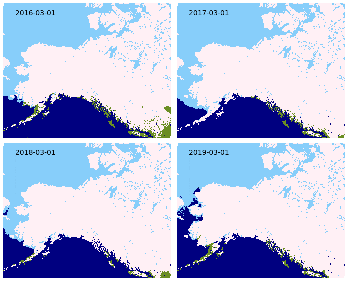
The above figure (R. E. Wolfe, et al. FIRMS US/Canada – An Extension of NASA Near Real-Time FIRMS for the Forest Service and Inter-agency Wildfire Management Community—Fig. 1) diagrams the extensive network of agency and institution partnerships that have been established to gather and serve fire detection data to meet fire agencies needs around the country.  With respect to the polar-orbiting satellites carrying some of these sensors, including VIIRS, Alaska find itself advantaged by twice as many daily satellite passes.  Even more exciting, the Alaska Satellite Facility (ASF)—in the Geophysical Institute on the UAF campus– downloads the raw data directly, without waiting for processing and server functions in the lower 48.  In the last couple years, ASF and GINA (Geographic Information Network of Alaska) have teamed up to feed VIIRS satellite detection hotspots directly to a digital map layer that can be accessed by fire managers less than one hour after the satellite passes.  Compare the simplicity of the Alaska model with the above path for MODIS “rapid-response” data!

Figure 2 VIIRS Data processing, based on information from Dr. Peter Hickman, UAF-GINA presentation at AGU: VIIRS Direct Broadcast Advances for Improved Wildland Fire Monitoring in Alaska.

This kind of state-of-the-art service has taken a lot of logistical planning, hard work, and scrambles for funding both at the University of Alaska as well as the Alaska Interagency Coordination Center.  The hard works pays dividends by giving fire management in Alaska a much needed boost against the background of longer, hotter fire seasons with flat suppression funding. 

Not only has the satellite “hotspot” data proved useful for finding fires, it also is boosting our ability to monitor, model, and predict fire spread.  A talk by Dr. Chris Waigl outlined how maximizing the use of three key remotely-sensed data streams:  snow-off date to help start fire danger index models, improved wall-to-wall rasterized visuals of fuel drying by region, and improved regional algorithms to maximize the accuracy and sensitivity of satellite hotspot identification, were all used to good effect by Alaska fire management in 2020.  Having the remotely sensed data to help with prioritization and decision-making was especially strategic during the COVID pandemic when managers were striving to spare staffing and reduce travel to rural villages.

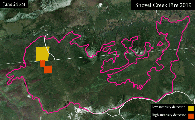
Figure 3 Example of VIIRS fire heat points use in fire spread monitoring, P. Hickman.

The potential utility of remotely-sensed data for wildfire management has been recognized by scientists and agencies for some time, but it’s not always easy to bring a product from the laboratory to the operations room.  There have been many discussions at various national levels and even a grassroots workshop in Fairbanks “Opportunities to Apply Remote Sensing in Boreal/Arctic Wildfire Management & Science”sponsored by NASA and facilitated by the Alaska Fire Science Consortium in 2017 addressing the potential application of remotely-sensed data.  And although the story seemed very successful, given the above, it’s not over!  Canada plans to launch the world’s first dedicated wildfire monitoring satellite constellation, WildFireSat, in 2025. And now we are thinking of ways to harness Artificial Intelligence for fire detection and spread monitoring!  Stay tuned.

List of the AGU talks/posters referenced with links:

Hickman, Pete; Jenkins, Jennifer; Schmunk, Gary; Delamere, Jennifer; Dierking, Carl; Cable, Jay; Wirth, Greg; Seaman, Curtis; York, Alison; Ziel, Robert. 2020, VIIRS Direct Broadcast Advances for Improved Wildland Fire Monitoring in Alaska. Talk, Presented at 2020 Fall Meeting, AGU, 15 Dec.

Waigl, Chris 2020, Science-to-Operations for Alaska Wildfire Management in Times of COVID-19: Usability Lessons from Rapid Data Tool Development. Talk, Presented at 2020 Fall Meeting, AGU, 15 Dec.

Wolfe, Edward; Quayle, Bard; Davies, Diana; Ederer Gergory; Olsina Otmar. 2020, FIRMS US/Canada – An Extension of NASA Near Real-Time FIRMS for the Forest Service and Inter-agency Wildfire Management Community. Talk, Presented at 2020 Fall Meeting, AGU, 15 Dec.

Ziel, Robert; Schmidt, Jennifer; Calef, Monika; Varvak, Anna. 2020, Detecting Temporal Changes in Land Cover Based on Disturbance in Alaska. Poster, presented at 2020 Fall Meeting, AGU, 15 Dec.

EPSCoR Boreal Fires Team: Remote Sensing for AK Fire Season

This Fire Science Highlight is available as a standalone online and PDF publication: https://tinyurl.com/FSHJuly2020

Can remote sensing products help mitigate the loss of on-the-ground resources due to the COVID-19 pandemic?

Chris Waigl and the EPSCoR Boreal Fires Science team are rapidly developing new tools to aid with the fire season in Alaska. Products include, enhanced access to daily snow cover extent and fire danger maps, and highly focused fire-detection algorithms. The tools aim to provide data that can be integrated into existing systems facilitating direct applications for users, including fire operation managers.

Remote sensing of daily snow cover extent

Spring 2020 saw the introduction of a new daily snow cover extent mapping product for the state of Alaska. The source data from the NOAA National Ice Center is based on near-real time readings from the Interactive Multi-sensor Snow and Ice Mapping System (IMS). This satellite multi-sensor can differentiate between snow, ice, water, and snow-free ground with high levels of accuracy. The snow cover product is available seasonally for download as a vector file and as web-browser map with near-real time updates through the Alaska Interagency Coordination Center (AICC) mapping service, and year-round (with limited updates) from the Boreal
Fires Team. Inter-annual comparisons of snow cover (Figure 1) can be made by geographic zone or throughout the state. This snow classification data could potentially be improved by validation through Moderate Resolution Imaging Spectroradiometer (MODIS) and Visible Infared Imaging Radiometer Suite (VIIRS) products, National Weather Service snow depth data, and citizen science projects that measure snow depth.

Figure 1. Inter-annual comparison of snow melt across Alaska and northwest Canada, 2016-2019. Green regions represent snow free areas. This animated comparison is just one way the data snow cover data can be visualized. The snow cover data can be obtained as a vector file, allowing for fine-scale pattern analysis within smaller geographic extents.

Improving access to spatial representations of Alaska Fire Danger Ratings

The Canadian Forest Fire Danger Rating System (CFFDRS) combines fire
occurrence prediction systems, fire weather indices, and fire behavior systems to establish a fire danger rating. MesoWest produces fire danger ratings from CFFDRS for Alaska. The Boreal Fires team helps make this data more accessible by processing the MesoWest GeoTIFFs into a format that can be more easily used for webmapping by AICC. These fire danger ratings are available on the AICC web-mapping service and also hosted by the Boreal Fires Team. The fire danger ratings, known as Spruce Adjective
Ratings, are grouped into low, moderate, high, very high, and extreme classes. These discrete groupings along with provincially specific parameters can create harsh differences in adjacent areas at province and international borders. CFFDRS has proven to have great application to Alaska. The Boreal Fires Team hopes that making the danger ratings more accessible will open the door for fine tuning the data to seamlessly fit Alaska, and lead to improved integration into fire behavior and analysis tools for the state.

Figure 2. Processing CFFDRS source data for Alaska creates an accessible spatial representation of Spruce Adjective Fire Danger Ratings. Fine tuning the application of the indices to Alaska could improve the interoperability of CFFDRS in Alaska.

VIFDAHL (VIIRS I-band Fire Detection Algorithm for High Latitudes)

VIIRS fire detection has shown to be invaluable for remote fire detection at high latitudes. VIFDAHL compliments VIIRS by subsetting high fire-danger areas and known fire locations. This information is particularly important for fire operations managers. Low-intensity detections have direct
application to spotting residual fire hazards, which can help with resource prioritization Having additional inputs for where fire is now, particularly
low-intensity detections, is helpful to identify ignition sources for fire behavior models.

Figure 3. VIFDAHL can provide up to two fire detections per day from satellite fly overs
providing valuable near-real time information. In this animation fire detections are shown
for the 2019 Shovel Creek Fire near Fairbanks. Some satellite flyovers produce no usable
information due to atmospheric interference such as clouds.