
This Fire Science Highlight is available as a standalone online and PDF publication: https://tinyurl.com/FSHJuly2020
Can remote sensing products help mitigate the loss of on-the-ground resources due to the COVID-19 pandemic?
Chris Waigl and the EPSCoR Boreal Fires Science team are rapidly developing new tools to aid with the fire season in Alaska. Products include, enhanced access to daily snow cover extent and fire danger maps, and highly focused fire-detection algorithms. The tools aim to provide data that can be integrated into existing systems facilitating direct applications for users, including fire operation managers.
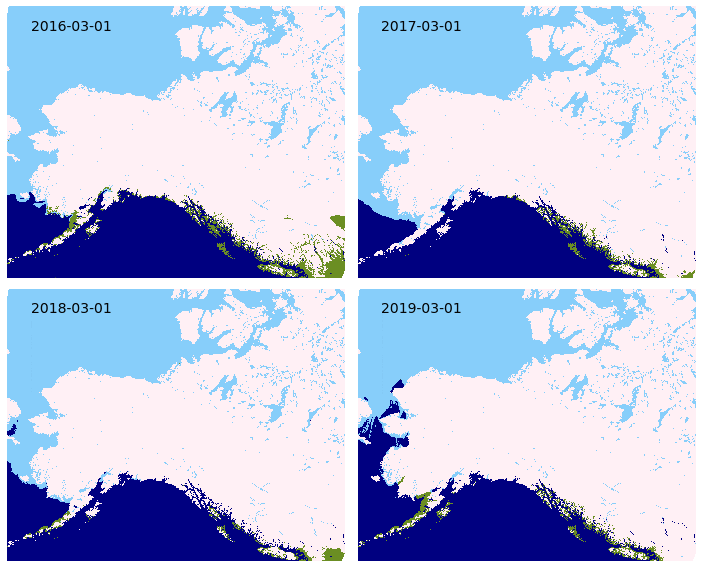
Remote sensing of daily snow cover extent
Spring 2020 saw the introduction of a new daily snow cover extent mapping product for the state of Alaska. The source data from the NOAA National Ice Center is based on near-real time readings from the Interactive Multi-sensor Snow and Ice Mapping System (IMS). This satellite multi-sensor can differentiate between snow, ice, water, and snow-free ground with high levels of accuracy. The snow cover product is available seasonally for download as a vector file and as web-browser map with near-real time updates through the Alaska Interagency Coordination Center (AICC) mapping service, and year-round (with limited updates) from the Boreal
Fires Team. Inter-annual comparisons of snow cover (Figure 1) can be made by geographic zone or throughout the state. This snow classification data could potentially be improved by validation through Moderate Resolution Imaging Spectroradiometer (MODIS) and Visible Infared Imaging Radiometer Suite (VIIRS) products, National Weather Service snow depth data, and citizen science projects that measure snow depth.
Improving access to spatial representations of Alaska Fire Danger Ratings
The Canadian Forest Fire Danger Rating System (CFFDRS) combines fire
occurrence prediction systems, fire weather indices, and fire behavior systems to establish a fire danger rating. MesoWest produces fire danger ratings from CFFDRS for Alaska. The Boreal Fires team helps make this data more accessible by processing the MesoWest GeoTIFFs into a format that can be more easily used for webmapping by AICC. These fire danger ratings are available on the AICC web-mapping service and also hosted by the Boreal Fires Team. The fire danger ratings, known as Spruce Adjective
Ratings, are grouped into low, moderate, high, very high, and extreme classes. These discrete groupings along with provincially specific parameters can create harsh differences in adjacent areas at province and international borders. CFFDRS has proven to have great application to Alaska. The Boreal Fires Team hopes that making the danger ratings more accessible will open the door for fine tuning the data to seamlessly fit Alaska, and lead to improved integration into fire behavior and analysis tools for the state.

VIFDAHL (VIIRS I-band Fire Detection Algorithm for High Latitudes)
VIIRS fire detection has shown to be invaluable for remote fire detection at high latitudes. VIFDAHL compliments VIIRS by subsetting high fire-danger areas and known fire locations. This information is particularly important for fire operations managers. Low-intensity detections have direct
application to spotting residual fire hazards, which can help with resource prioritization Having additional inputs for where fire is now, particularly
low-intensity detections, is helpful to identify ignition sources for fire behavior models.
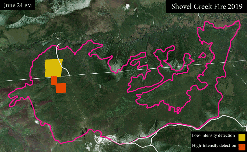
providing valuable near-real time information. In this animation fire detections are shown
for the 2019 Shovel Creek Fire near Fairbanks. Some satellite flyovers produce no usable
information due to atmospheric interference such as clouds.
