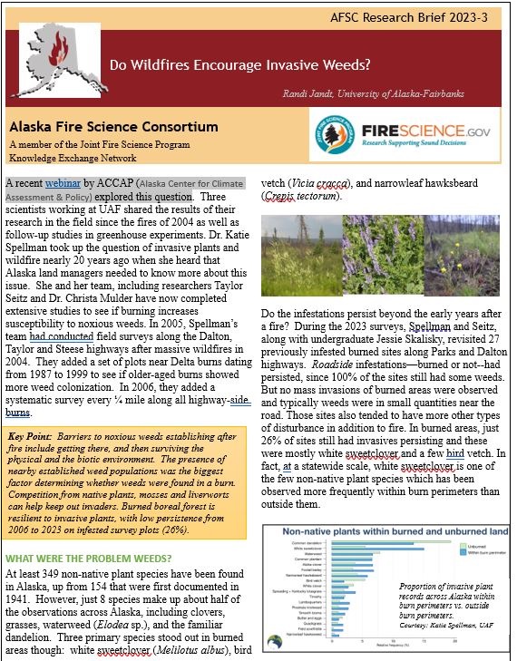
Do Wildfires Encourage Invasive Weeds?

A recent webinar by ACCAP (Alaska Center for Climate Assessment & Policy) explored this question, and is summarized in AFSC’s latest Research Brief (available HERE). A research team at UAF led by Dr. Katie Spellman shared the results of their research in the field since the fires of 2004 as well as follow-up studies in greenhouse experiments. Spellman took up the question of invasive plants and wildfire nearly 20 years ago when she heard that Alaska land managers needed to know more about this issue.

Download the Research Brief or watch the Aug 22, 2023 recorded webinar:

Wildfire and Invasive Plants in Alaska’s Boreal Forest

and Q&A session at ACCAP’s website: https://uaf-accap.org/event/wildfire-invasive-plants/

Findings from Alberta’s Ft.McMurray Fire

Fires on both sides of Ft. McMurray May 1, 2016

Alberta’s Cordy Tymstra discusses decisions facing fire managers during the 2016 Ft. McMurray fire.

Alaskans were paying close attention in 2016 when a spring firestorm called Horse River burned over a Fairbanks-sized Alberta town resulting in unprecedented evacuation of 90,000 people with insurable losses over $3.77 billion so far.  The disaster even had a negative impact on Canada’s National GDP–at 1.5 million acres it was the 3rd largest fire in Canada’s history. What have we learned from this catastrophic fire and can we co-exist with fire? Fire researcher Mike Flannigan, and Alberta’s fire science and prevention officer Cordy Tymstra teamed up on an important webinar for the AFSC last fall (watch it on our AFSC Vimeo Channel).   Mike gave us a lot of additional insights into fire ecology:  like the number of fires in Canada has doubled since the 1970’s, and spring fires are becoming increasingly important.  Cordy provided intimate “behind-the-scenes” looks into decision-making and the challenges faced by fire managers.  On May 5th, for example, the fire’s rate of spread was estimated at 2.86 km/hr (0.8 m/sec).  The pyrocumulus clouds that developed deposited firebrands up to 35 km ahead of the main fire.  Half of the discussion focused on recommendations from the after-action review:  for example, Alberta moved their official fire season start up to March 1.  They are going to review Incident Commander qualifications for WUI incidents and work on more ICS training for municipal cooperators.  And they are going to ramp up their provincial FireSmart program.  These are just a few.  Watch the presentation:  it will be an hour well-spent.

Fire’s Role in a Broadleaf Future for Alaska?

As climate warming brings more wildfire to the North, scientists and citizens wonder how the landscape will be transformed.  Will forests continue their 2000’s-era trend toward less spruce and more hardwoods, catalyzed by larger fires and more frequent burning?  If so, that might slow down the trend for larger and more intense fires. However, will hotter summers with more effective drying lead to increased fire re-entry into the early successional hardwoods, making them less strategic barriers for fire protection? A research team modeling the former question just unveiled an interactive web tool to model forest changes under various future climate scenarios (Feb. 1 webinar recording available HERE).  With the new web tool, funded by JFSP,  Paul Duffy and Courtney Schultz will be working with fire managers in Alaska to look at fire occurrence and cost in the future.  Try it for yourself at  http://uasnap.shinyapps.io/jfsp-v10/

video-only-site-roadsite-burnout-7
Photo by USFS, PNW (2004).

As for the second question–will it be harder for hardwoods to resist fire–a recent paper in Ecosphere (Barrett et al. 2016) is one of the first published studies to look for an answer.  AFSC highlights that work with a Research Brief this month: A Deeper Look at Drivers of Fire Activity, Re-burns, and Unburned Patches in Alaska’s Boreal Forest.  Check out all our Research Briefs in our web Library.

Citation: Barrett, K, T. Loboda, AD McGuire, H. Genet, E. Hoy, and E. Kasischke. 2016. Static and dynamic controls on fire activity at moderate spatial and temporal scales in the Alaskan boreal forest. Ecosphere 7(11):e01572. 10.1002/ecs2.1572

Fire and Carbon Stores: the Rest of the Story

Estimates of carbon released from combustion of vegetation and organic soil during wildfires have improved dramatically over the past decade.  Biomass inventory, fire effects and fire severity studies have contributed more accurate data to improve these models. (See Ottmar 2007, Brendan Rogers webinar 2015)  However, figuring out the net effect of all the various effects of fire, the recovery phase and warming climate on the carbon stored in Alaska’s forests and tundra is a lot more challenging!  You’d have to consider changes in burn extent and/or severity, increases in plant productivity in recovering burns, changes in species composition and what that means for productivity, changes in permafCaptureIEMrost distribution and soil C decomposition, methane emissions and carbon fluxes in lake systems and wetlands–etc.!  A team lead by Dr. Dave McGuire at UAF has taken on this modeling challenge by applying their Integrated Ecosystem Model (IEM) which includes modules for fire, permafrost, and carbon cycling. Dave recently presented an overview of their findings at an IARPC-WCT/AFSC joint webinar (available HERE).  In a nutshell, they found: 1) tundra holds 2x the carbon that boreal forest does in the same area 2) there has been a net C loss from boreal land area of about 8 Tg/yr over the last 60 years, primarily driven by large fires during the 2000’s 3) arctic tundra and SE Alaska still act as C sinks, compensating for these losses so that overall, Alaska sequesters about 3.7 Tg/yr,  4) increases in fire extent predicted with with warming climate will release even more C, but longer growing seasons and increased plant growth (as much as 8-19% increased productivity throughoCaptureALFut the remainder of this century) with warmer climate and higher CO2 concentration in the atmosphere are estimated to offset these losses under most of the climate projection scenarios. Since this nutshell summary glosses over a lot, you should take a look at the presentation and the SNAP projects page with information on scenarios and the individual models used.

Upcoming webinar: Effect of Tundra Fires on Post-fire Vegetation

Teresa Hollingsworth, USFS and Amy Breen, UAF-SNAPTundra_Fire


Apr 28, 2014  2:00 pm – 3:00 pm  AK time. Register.

https://akfireconsortium.uaf.edu >> Events

Amy and Teresa will summarize the history of tundra fires in Alaska and share preliminary results of their research to characterize post-fire plant communities, quantify fuel accumulation, and model tundra fire regimes and vegetation dynamics.

Find the recorded webinar <HERE>.


Webinar about Black Carbon in the Atmosphere

Tundra_Fire

National experts will be giving a talk to bring you up to speed on this issue if you’d like to know more about sources of soot in the atmosphere (including wildfire) and whether pollution control efforts are having any effect.  Speakers include: In-situ ground sensing: Patricia Quinn (NOAA);  Satellite remote sensing: Ralph Kahn (NASA); and Transport modeling: Mark Jacobson (Stanford).

Date: April 18, 2014  Time: 3:00-4:30 EDT (that’s 11:00-12:30 Alaska Daylight time)   Register at IARPC Collaboration website.

Find the recorded webinar <HERE>

The Atmosphere Collaboration Team of the Interagency Arctic Research Policy Committee (IARPC) is hosting the second of two webinars on black carbon which are open to the community. The intent of the second webinar is to share information about current science questions and activities related to Arctic black carbon. Experts will be on hand to share information and answer questions in an effort to inform the Atmosphere Collaboration Team of IARPC of possible future interagency activities related to Arctic black carbon.

Webinar Synopsis

Black carbon is “the second most important human emission in terms of its climate-forcing in the present-day atmosphere; only carbon dioxide is estimated to have a greater forcing.” When BC is deposited on snow and ice, it darkens an otherwise bright surface. The darker surface may enhance the absorption of solar radiation resulting in an acceleration of snow and ice melting. In addition, BC particles suspended in the atmosphere absorb solar radiation and heat the surrounding air. Atmospheric BC can also alter cloud properties leading to changes in cloud amount and precipitation. Black carbon has multiple sources including domestic combustion for heating and cooking, diesel combustion related to transportation, fossil fuel and biofuel combustion for power generation, agricultural burning, and wildfires. Identification of the sources and types of black carbon (both the geographical region of the source and the combustion process) is necessary for effectively mitigating its climate impacts. In addition, measurements of black carbon are required to verify whether implemented mitigation strategies that target BC emissions from certain sources are actually leading to reductions in BC concentrations in the Arctic atmosphere and surface. In 2013, NOAA’s Arctic Report Card added a black carbon assessment to the Atmosphere Section; the primary conclusions of the assessment are that (1) the average equivalent black carbon concentrations in 2012 at locations Alert (Nunavut, Canada), Barrow (Alaska, USA) and Ny-Alesund (Svalbard, Norway) were similar to average EBC concentrations during the last decade and (2) equivalent black carbon has declined by as much as 55% during the 23 year record at Alert and Barrow (Sharma et al. 2013).

 

Webinar Recording Available– 2013 Alaska Fire Modeling Lessons Learned


Lisa Saperstein, USFWS, Brian Sorbel, NPS, and Robert Ziel, DOFFireModelingLessons

Wed, March 5, 10:00 am. Visit our Vimeo page to view all our recorded webinars or find the recording <HERE>.

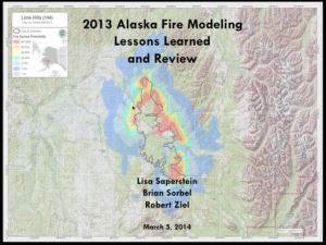
Organized by the Alaska Fire Modeling and Analysis Committee, this webinar employed an expert panel to look back at some of the modeling work that occurred in 2013, specifically focused on lessons learned that can be carried forward into 2014.  Some important points covered–what’s the difference between fire modeling in FSPro vs. Canadian BEHAVE system; how to tweak landscape cover and crown fire models to get reasonable results; using auxiliary information like Google Earth, Landsat imagery, and MODIS hotspots to inform your run.  Don’t forget, there is a manual–available on the FMAC page above!: FSPro Analysis in Alaska: A Users Guide

(Image: 7 day fire spread probability of Lime Hills fire, June 24, 2013, and June 30 perimeter (black line). Courtesy Lisa Saperstein.)

Webinar Summary: What do Forest Fires, Caribou, and Monster Truck Tires have in Common? by Matt Nolan

Dr. Matt  Nolan shared results from his recent airborne photogrammetry campaigns in Alaska, and related them to possible fire and forest management applications in a webinar on February 25, 2014.  There is now a 2-page Webinar Summary about the topic and you can also watch the recorded webinar on AFSC’s website <HERE>.  Dr. Nolan is a Research Associate Professor at UAF’s Institute of Northern Engineering with degrees in geophysics and arctic and mechanical engineering. He’sNolan-Webinar-2014-THUMB_Page_1 been pioneering new high-tech uses of an old tool—the aerial photo.  With new advances in computer processing and display technologies, airborne Digital SLR Photogrammetry is an even more powerful tool for field sciences, especially in remote areas like Alaska. Compared to LiDAR (Light Detection and Ranging, or aerial 3D laser scanning), the low cost of DSLR photogrammetry makes it more affordable to make time-series of high-resolution maps, opening up  new possibilities for analyzing and understanding changes in the environment. Forest inventory, fire fuels assessments (like canopy height), snow depth, and post-burn vegetation recovery and monitoring are just a few examples of applications that could benefit from time-series of topographic measurements on an annual, monthly, or other repeating basis.

Dowload Webinar Summary <<LINK>>

Did you miss this December Webinar? Video of “What is live fuel moisture: a new look at the combustion of living plants” is available for viewing!

Matt Jolly, PhD, from the USFS Fire, Fuel and Smoke Science Program, Missoula Fire Sciences Laboratory presented the webinar on December 20th.  You can watch it on YouTube thanks to the Great Lakes Region Fire Consortium  at http://www.youtube.com/watch?v=dAEYk2pEdJM

Live fuel moisture is measured frequently throughout the country as an indicator of potential fire behavior but little is known about the primary factors that drive their seasonal variations. Dr. Matt Jolly delves into the interactive factors that control live fuel moisture and discusses some of the potential implications of these factors on seasonal variations in the fire potential of living plants. He shows how the interactions between the water content of the foliage and seasonal changes in the leaf’s dry weight combine to influence calculated live fuel moisture and ultimately, its flammability.

By akfireconsortium Posted in Webinars

Feb 25 Webinar on WIMS by the Alaska Fire Applications and Modeling Committee

ImageJan Passek, USFWS Fire Specialist, and Heidi Strader, Weather Forecaster from the Alaska Interagency Coordination Center will demonstrate how to input daily weather observations used  to  calculate Fire Danger using WIMS–the Forest Service Weather Information Management System!  The Webinar is 1:30 p.m. AST on Monday, February 25th. Come join the webinar as we discuss: WIMS Roles and responsibilities, Access Control Lists- what are they, who controls them?, NFDRS, Firefamily Plus, Weather Detective skills and what to look for Monday mornings to ensure weekend weather is updated. Registration information is available from ayork@alaska.edu.

Link to recording <HERE>