The Alaska Wildland Fire Coordinating Group, representing agencies and land managers involved in managing wildfire has a Fire Research and Applications Committee (FRDAC). Periodically, the committee surveys members and collaborators to see what they consider to be the most important current areas of wildland fire research in the Alaska region. Science providers, in particular, may be interested in this management perspective on research. At last week’s interagency Fall Fire Review, committee chair Jennifer McMillan discussed top-ranked categories of fire effects, fuel treatments, and environmental/land cover change identified by the survey. For example, AWFCG members expressed interest in more research into fire effects on moose/caribou populations, subsistence lifestyles, migration patterns and berry production. For fuel treatments, the areas identified were treatment longevity and effectiveness, maintenance, and biodiversity and habitat responses. Expanded briefs (with citations) on 3 critical research gaps are located on our partner page for FRDAC: https://www.frames.gov/afsc/partners/frdac/research-needs
Can’t help but notice with this year’s fires in interior Alaska, some burned readily into recent (<20 year old) burn scars, like the Delta fire, Hillbilly and Ponds fires southeast of Fairbanks (figure). Fires to the southwest (Clear Ck and Rock Ck) are re-burning 1950’s and 1960’s burn scars but more recent burn perimeters seem to be working as fuel breaks. Fire management agencies in Alaska have traditionally relied on burn scars to act as fuel breaks, stopping or significantly moderating fire spread, for up to 50 years post-fire (Cronan and Jandt, 2008). In the 21st century, however, the phenomenon of early fire re-entry into old burns is becoming more common (Barnes 2017, Buma 2022).
While a student at UAF, Rafael Rodriguez (forestry technician with the State of Alaska in Fairbanks) showed a strong correlation between the number of times an area had burned between 1940-2010 with mean July temperature (Rodriguez 2014). In 2023, late July and August brought ideal weather for late season wildfires to the interior. Burning still exerts a strong negative feedback on re-burning within 10 years of a fire, and overall only about 4% of burned area in Alaska has burned more than once in the last 30 years (Buma, et al. 2023). Still the phenomenon of early fire re-entry, driven both by warming climate/drying fuels and by forest conversion to grassland or scrub, is very impactful for fire management decisions and agencies are carefully monitoring the trend.
Dr. Jen Schmidt (UAA) and retired Alaska forester John See tackle several practical questions about wildfire risk for residents of the Anchorage area in the new, illustrated 75-page report Advancing Wildfire Preparedness and Planning in Anchorage. The study was part of the Arctic Urban Risks and Adaptations (AURA) project, funded by the National Science Foundation. A few highlights can be found in our latest Research Brief–>>HERE.
Many of you will find practical tools and info here that hit pretty close to home! The full report can be located at the project website under “EGRESS” here: https://sites.google.com/alaska.edu/jenschmidt/wildfire/aura/wildfire-exposure. Don’t forget to check the level of wildfire exposure for your own property with the tools on the site! The best way to avoid losses is to do some advance planning and preparation.
Many other interesting materials can be downloaded at the AURA site, like maps of fuel treatments, wildfire videos, and this map of burn severity on the 2019 McKinley fire that Schmidt and her team created.
Alaska Midnight Sun crew boards a bus to head for a Canadian fire assignment June 4, 2023 (Photo credit: Beth Ipsen, BLM Alaska Fire Service)
Why is the Alaska fire season so quiet this year while Canada has major wildfires? Alaska climatologist Rick Thoman attributes the lack of fires in Alaska (only 934 acres burned by the end of June) to a lack of lightning as well as cooler, moister weather this year (Alaska June 2023 Sea Ice and Wildfire). Interesting that this year Alaska retained a lot more sea ice in the Chukchi sea and Arctic Ocean above Barrow: there is some evidence linking regional climate to sea ice concentration (Zou, et al. 2021). Meanwhile, Canada is breaking records with 22.7 million acres burned (9.2 million ha) as of July 9. CiFC (https://ciffc.ca/) reports 3,678 fires spread across the entire country. Canadian and US cities (including Detroit, Pittsburgh, and Chicago) have been suffering poor air quality for much of the mid-summer with little relief in site. Is there an explanation for the unusual pattern? The global temperature anomaly for May (figure) may be one clue. Strong linkages have been found between warm temperatures and wildfire activity, mainly because of accelerated drying of vegetation fuels. In the western US, Abatzoglou and Williams (2016) found that human-caused climate change caused over half of the documented increases in fuel aridity since the 1970s and doubled the cumulative forest fire area since 1984. At any rate, 2023 brought very little snow to eastern Canada, so it melted early and Fire Weather Indices have been unusually high.
Figure from Scott Duncan (ScottDuncanWX@twitter.com)
Fire regime is changing in other parts of the world. Rebecca Scholten is finishing up a PhD in Amsterdam studying weather patterns which correlate with fire activity around the north, especially arctic areas. She’s noted that changes in the polar jet stream driven by warming global temperature seem to be correlated with more wildfire in northern tundra ecosystems. A simplified explanation would be that a “wobbly” polar jet stream caused by weaker cold sink over the Arctic can mean calming in mid-latitudes but intense heat domes, dry and windy conditions, and more convection over high northern latitudes. There seems to be a strong link with these conditions and the Siberian megafires in 2019-2021. Her recent paper in Science points to accelerating changes in high latitudes with earlier snowmelt and a tripling in the frequency of this “Arctic front jet pattern.” Curiously, when this pattern sets up, it may moderate conditions–at least with respect to winds–over interior Alaska!
Citations:
Zou, et al 2021. Increasing large wildfires over the western United States linked to diminishing sea ice in the Arctic. Nat Commun 12, 6048. https://doi.org/10.1038/s41467-021-26232-9
Abatzoglou and Williams. 2016. Impact of anthropogenic climate change on wildfire across western US forests. PNAS 113 (42) 11770-11775. https://doi.org/10.1073/pnas.1607171113
Scholten, R.C. et al. 2022. Early snowmelt and polar jet dynamics co-influence recent extreme Siberian fire seasons. Science 378, 1005–1009. https://doi.org/10.1126/science.abn4419
Can remote sensing products help mitigate the loss of on-the-ground resources due to the COVID-19 pandemic?
Chris Waigl and the EPSCoR Boreal Fires Science team are rapidly developing new tools to aid with the fire season in Alaska. Products include, enhanced access to daily snow cover extent and fire danger maps, and highly focused fire-detection algorithms. The tools aim to provide data that can be integrated into existing systems facilitating direct applications for users, including fire operation managers.
Remote sensing of daily snow cover extent
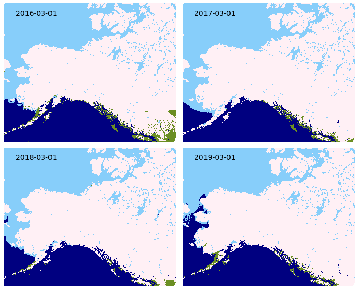
Spring 2020 saw the introduction of a new daily snow cover extent mapping product for the state of Alaska. The source data from the NOAA National Ice Center is based on near-real time readings from the Interactive Multi-sensor Snow and Ice Mapping System (IMS). This satellite multi-sensor can differentiate between snow, ice, water, and snow-free ground with high levels of accuracy. The snow cover product is available seasonally for download as a vector file and as web-browser map with near-real time updates through the Alaska Interagency Coordination Center (AICC) mapping service, and year-round (with limited updates) from the Boreal Fires Team. Inter-annual comparisons of snow cover (Figure 1) can be made by geographic zone or throughout the state. This snow classification data could potentially be improved by validation through Moderate Resolution Imaging Spectroradiometer (MODIS) and Visible Infared Imaging Radiometer Suite (VIIRS) products, National Weather Service snow depth data, and citizen science projects that measure snow depth.
Figure 1. Inter-annual comparison of snow melt across Alaska and northwest Canada, 2016-2019. Green regions represent snow free areas. This animated comparison is just one way the data snow cover data can be visualized. The snow cover data can be obtained as a vector file, allowing for fine-scale pattern analysis within smaller geographic extents.
Improving access to spatial representations of Alaska Fire Danger Ratings
The Canadian Forest Fire Danger Rating System (CFFDRS) combines fire occurrence prediction systems, fire weather indices, and fire behavior systems to establish a fire danger rating. MesoWest produces fire danger ratings from CFFDRS for Alaska. The Boreal Fires team helps make this data more accessible by processing the MesoWest GeoTIFFs into a format that can be more easily used for webmapping by AICC. These fire danger ratings are available on the AICC web-mapping service and also hosted by the Boreal Fires Team. The fire danger ratings, known as Spruce Adjective Ratings, are grouped into low, moderate, high, very high, and extreme classes. These discrete groupings along with provincially specific parameters can create harsh differences in adjacent areas at province and international borders. CFFDRS has proven to have great application to Alaska. The Boreal Fires Team hopes that making the danger ratings more accessible will open the door for fine tuning the data to seamlessly fit Alaska, and lead to improved integration into fire behavior and analysis tools for the state.
Figure 2. Processing CFFDRS source data for Alaska creates an accessible spatial representation of Spruce Adjective Fire Danger Ratings. Fine tuning the application of the indices to Alaska could improve the interoperability of CFFDRS in Alaska.
VIFDAHL (VIIRS I-band Fire Detection Algorithm for High Latitudes)
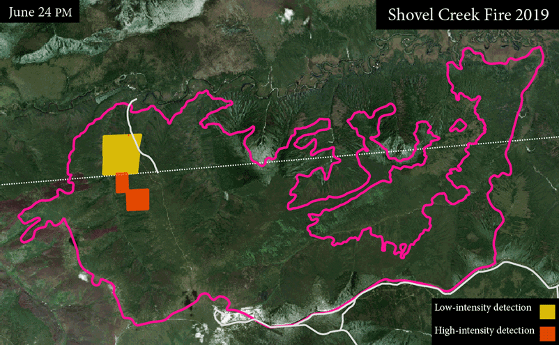
VIIRS fire detection has shown to be invaluable for remote fire detection at high latitudes. VIFDAHL compliments VIIRS by subsetting high fire-danger areas and known fire locations. This information is particularly important for fire operations managers. Low-intensity detections have direct application to spotting residual fire hazards, which can help with resource prioritization Having additional inputs for where fire is now, particularly low-intensity detections, is helpful to identify ignition sources for fire behavior models.
Figure 3. VIFDAHL can provide up to two fire detections per day from satellite fly overs providing valuable near-real time information. In this animation fire detections are shown for the 2019 Shovel Creek Fire near Fairbanks. Some satellite flyovers produce no usable information due to atmospheric interference such as clouds.
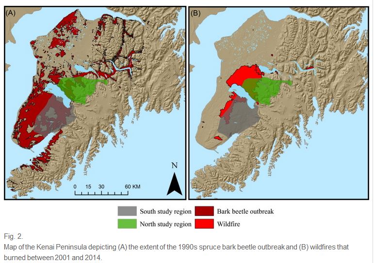
It has long been assumed that bark beetle outbreaks on the Kenai lead to increased fire danger, even though beetle disturbance has been shown to have mixed effects on crown fire potential, fuel profiles and burn severity in the Rocky Mountains. Winslow Hansen, doctoral candidate at the University of Wisconsin, recently published an analysis of beetle outbreaks and fire on the Kenai Peninsula between 2001-2014 (Hansen et al. 2016). He looked at effects in pure white spruce stands–where duration of beetle attacks is longer and mortality greater–and in mixed white and black spruce stands common on the northern peninsula, where attacks are less severe. His analysis indicates mixed effects: severely damaged white spruce stands did not demonstrate increased fire occurrence (instead, % canopy cover appeared to drive likelihood of burning) while the mixed white/black spruce stands didshow a positive correlation with beetle outbreaks and fire. Winslow explores the reasons for this in his relatively short article: worth reading. You may remember Winslow from his previous work on beetles/fire effects and property values on the Kenai (recorded MS Thesis defense) and climate effects on fire regime (recorded 2015 presentation).
UNIversity FORmation Mission 1–microsatellite designed by Hokkaido University for wildfire management (photo: Koji Nakau)
Hokkaido University (HU) is one of the world leaders in developing new earth-observing space technology. Dr. Koji Nakau leads their wildfire remote sensing applications team. He’s working with various partners—including UAF—on new satellite-derived products delivered to wildland fire managers in Alaska and around the world. They are especially excited about the May 24th (2014) launch of a rocket carrying ALOS-2 (Advanced Land Observing Satellite) which is also carrying a couple microsatellites with sensors specifically designed by his team to detect wildfire signatures. In addition to improving real-time operational support, satellite data is analyzed in support of wildfire propagation modeling, smoke transport, fuels estimates, and post-fire ecology.
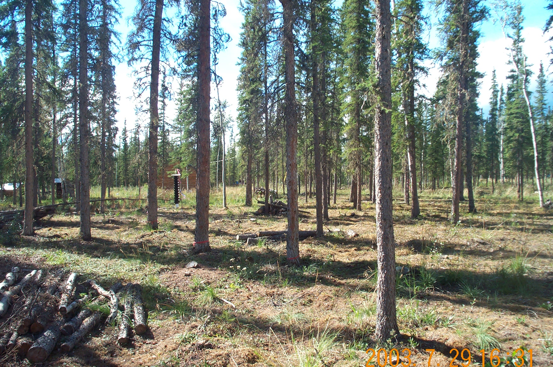
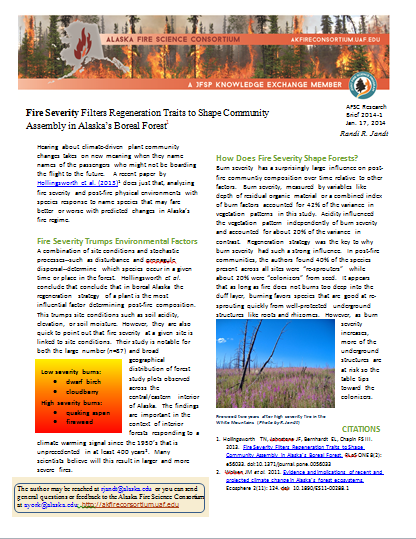
Fire Severity Filters Regeneration Traits to Shape Community Assembly in Alaska’s Boreal Forest: A recent paper by Hollingsworth et al. (2013) proposes that fire severity and a plant’s intrinsic regeneration strategy are key determinants in post-fire community recovery. The authors identify species that may fare better or worse with predicted changes in Alaska’s fire regime. Hollingsworth–who is based at the University of Alaska-Fairbanks–bases her findings on a large (n = 87) and geographically diverse set of post-fire plots in interior Alaska boreal forest.
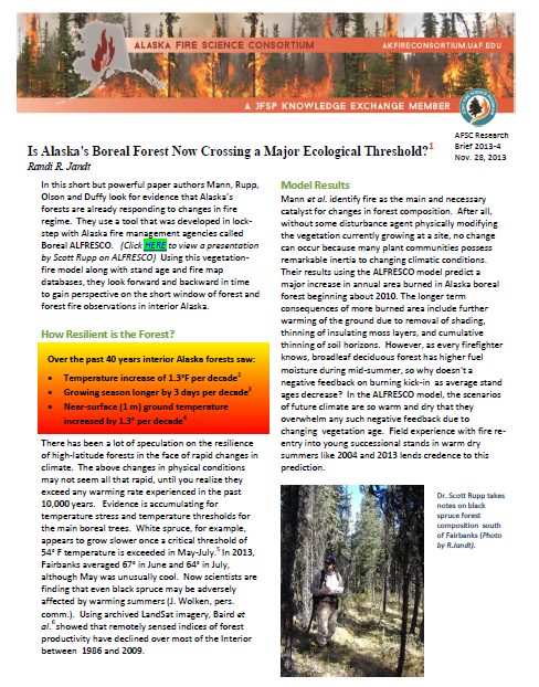
Is Alaska’s Boreal Forest Now Crossing a Major Ecological Threshold?: Read up on what Alaskan forest and climate research has found out about the influence of warming climate on boreal forests in the Interior! Here’s a new 2-page Research Brief that digests one of the more significant papers on forest and climate change. The authors– Dan Mann, Scott Rupp, Mark Olson and Paul Duffy– are well-known to Alaska fire managers. This is a good basis to our upcoming focus on multi-faceted influences of dynamic climate on fire regime, forests, and fire management in Alaska in 2014!
Global wildland fire season severity in the 21st century: A 1-page research brief summarizes a recently published article by Canadian fire scientist Mike Flannigan of the University of Alberta. Dr. Flannigan is well-known in Alaska fire management circles due to his contributions to boreal forest wildfire studies and the Canadian large fire database. This 2013 article describes the use of component indices of the Canadian Fuels Danger Rating System to forecast future changes in fire season severity world-wide.
Download >> | Research Brief (pdf, 180 kb) or link to the full scientific article.
ACCAP hosted a webinar with Dr. Flannigan in July 2013. Watch the recording here.