Pondering Climate Change and Alaska Fire Regime

card streeet smoke plume

Smoke plume from the 2015 Card Street fire in Alaska (Photo: Alaska Division of Forestry)

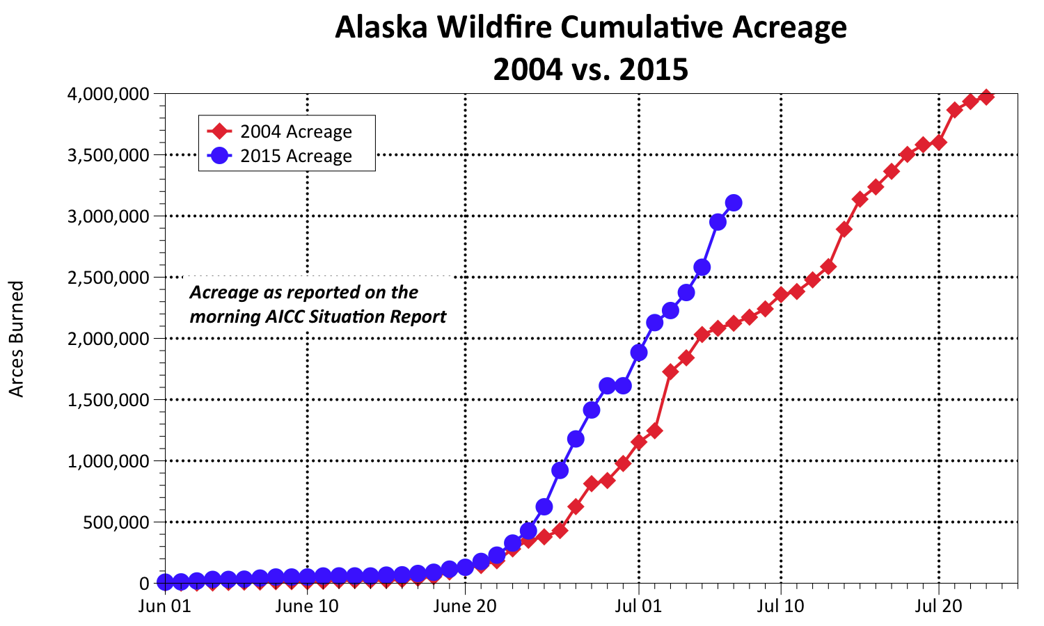
In the aftermath of Alaska’s 2nd largest fire season in 2015, followed by a record-breaking warm winter & spring (again) people are wondering if climate warming may be partly to blame.  With Alaska warming twice as fast as the western US, it seems fire regime change is already upon us–and starting to receive national attention.  Three new fire science research proposals were just funded for the Alaska region to look help understand and plan for these changes:  The national Joint Fire Science Program funded “Implications for Operational Costs and Complexity under Future Scenarios“and “Alaskan Tundra Fires During a Time of Rapid Climate Change“.  Both proposals attempt to help fire managers cope with climate-induced changes in the boreal fire regime and address research priorities of the Alaska wildfire management community. A third proposal “Seasonal Climate Forecasting Applied to Wildland Fire Management in Alaska” was funded by NOAA to investigate the large-scale climate drivers of fire weather in Alaska with a focus on lightning, temperature, and precipitation and expand the forecasts and tools available to fire managers. It’s not just high latitudes feeling the heat–a recent piece by the New York Times interviewed fire managers and ecologists around the country for their take on changes: http://www.nytimes.com/2016/04/13/science/wildfires-season-global-warming.html  And if you want to see how another hot news item–  politics!!–might play into wildland fire, see this interesting new report by Joint Fire Science Program:  Scanning the Future of Wildfire: Resilience ahead whether we like it or not!


Western Forester Article on Fuel Breaks in Alaska

The first 2016 issue of Western Forester contains a pair of short articles on the Nenana Ridge crown fire experiment and fuel break effectiveness at Funny River and the studies in progress on fuel break effectiveness in Alaska.  Eric Miller (BLM-Alaska Fire Service) and Nathan Lowjewski (Chugachmiut Forester) did a nice job on these write-ups!  Eric’s article gives the first published account of what happened in 2016 when wildfire challenged a 10-year old thinned fuel break in black spruce, as well as insight to the “hows” and “whys” of fire behavior in fuel breaks.  Here’s a link to the issue:  http://www.forestry.org/media/docs/westernforester/2016/WFJanFeb2016-2_LT3qttf.pdf

DSCF0696

The Yukon Hot Shot Crew puts finishing touches on experimentally thinned fuel treatment blocks in June, 2007 (R.Jandt).

Michigan Scientists Integral to Wildand Fire Research in Alaska

You might be surprised by the amount of collaboration between Alaska and Michigan-based scientists over the last 2 decades!  This has been a long-standing research relationship which has spawned many useful products–including Alaska’s fire perimeter map database!  Other endeavors include satellite fire detection and mapping, fuel moisture detection, improvements in fuels mapping, tundra fire research and more. Read about the history of this research relationship and its important findings and products, still ongoing with some exciting current research endeavors in a new Research Brief (LINK).

Nov. 2015 Research Brief, 3pp

Nov. 2015 Research Brief, 3pp

Wildland Fire Science in Alaska Gets Help From ABoVE

NASA’s Arctic Boreal Vulnerability Study (ABoVE) has focused a research spotlight on Alaska & Canada this year.  In August, 2015, they announced 21 new projects funded for a multi-year field campaign designed to investigate the ecological and social impacts of changing permafrost, wildfires, and wildlife habitats in Alaska and northwestern Canada.  Many of these involve new approaches to use remote sensing information from satellites.  At least 5 funded projects involve field work in Alaska and direct involvement with the wildfire science and/or management in Alaska.  Read about the new ABoVE projects at:

http://above.nasa.gov/cgi-bin/above/search_projects.pl?action=4&sol=Terrestrial%20Ecology%20%282014%29

Randi Jandt & Dave Yokel sample a sea of cottongrass 4 years after the Anaktuvuk River fire in Alaska.

Randi Jandt & Dave Yokel sample a sea of cottongrass 4 years after the Anaktuvuk River fire in Alaska.

Fire Weather Indices in Alaskan Tundra Expected to Respond to Climate Warming: New Article

A multi-decadal analysis of fire in Alaskan tundra ecotones was completed using records from the Alaska Large Fire Database and an analysis of future fire potential was performed based on future climate scenarios and the Canadian Fire Weather Indices (FWI).  The authors analyze tundra fire potential in different tundra areas and conclude that most areas will see substantial increase in the number of high-fire-potential days in the next few decades.  This figure shows, for example, the Seward Peninsula and Southwest areas with historical (1951-2005) fire weather indices and modeled with 3 different climate projections to 2095.  Although the Seward Peninsula FWI only exceeded 20 twice in the historical record (1977 & 2005), it is projected to exceed 20 much more frequently in the  next decades.  Read the full article:  French, N. H. F., L. K. Jenkins, T. V. Loboda, M. Flannigan, R. Jandt, L. L. Bourgeau-Chavez, and M. Whitley, 2015: Fire in arctic tundra of Alaska: past fire activity, future fire potential, and significance for land management and ecology. Int. J. Wildland Fire, http://dx.doi.org/10.1071/WF14167.

Historical and projected Fire Weather Index values over Seward Peninsula, from French et al. 2015. Black represents modeled historical FWI and colors represent modeled future FWI for the three IPCC RCPs evaluated.

Historical and projected Fire Weather Index values over Seward Peninsula, from French et al. 2015. Black represents modeled historical FWI  (to 2005) and colors represent modeled future FWI for the three IPCC RCPs evaluated.

Modeling Alaska Fire Growth Potential

Here in interior Alaska a lot of us have been thinking about the potential for fire growth lately: as in how big could these fires actually get in 2015?  The graph below (thanks to Rick Thoman from the Alaska Climate Center-UAF for tracking this data) shows how the cumulative acres burned compares with the Season-of-Never-Ending-Smoke 2004.  As you can see, we’re well on our way to a new record year, barring a significant turn of weather patterns.  It just so happens a very interesting presentation on modeling fire growth was presented to the May 2015 American Meterological Society Conference and that paper is now available and posted on the Alaska Fire Science Consortium website: MODELING FIRE GROWTH POTENTIAL BY EMPHASIZING SIGNIFICANT GROWTH EVENTS:CHARACTERIZING A CLIMATOLOGY OF FIRE GROWTH DAYS IN ALASKA’S BOREAL FOREST by Robert Ziel, Jane Wolken, Tom St. Clair, and Marsha Henderson.

The authors show that MODIS hotspot data can be used as fire growth data to evaluate multi-day fire growth models such as FS-Pro since 97% of MODIS hotspot data correlated with final fire perimeters.  Predicting fire growth potential based on thresholds for weather and fuel moisture conditions required a climatological analysis of the conditions occurring throughout the interior Boreal ecoregion, and an analysis was conducted on the conditional frequency of the fire events (represented by MODIS detects) that occur under the range of weather and fuel moisture conditions found in the climatology.

7-6-15-Thoman-graph

Alaska WFDSS Training for FMOs and Agency Administrators

Watch how-to videos on completing different parts of the WFDSS process on your incident

Watch how-to videos on completing different parts of the WFDSS process on your incident

Training modules on using the Wildland Fire Decision Support System (WFFDSS) in Alaska are now available on the AFSC website.  Find a video, from 5 to 30 minutes long, on the section you’re interested in or download a step-by-step annotated Powerpoint taking you all the way from Login to Publishing a decision.

What is the moisture content of standing dead grass?

Blackline WR4-TXrange2007-crop

April 2007 burning standing dead grass on Texas Range near Delta using a terra-torch (BLM-AFS).

Eric Miller, BLM Alaska Fire Service Fire Ecologist, assists with a lot of prescribed burns on military training ranges in Alaska where the primary fuel is standing dead grass (photo) and this question was often on his mind. He found that existing fine dead fuel moisture tables underestimated the moisture content in dead grass. Six years and 74 prescribed burn days later he had collected 409 grass samples and 285 weather observations, enough to build several empirical- and process-based fuel moisture models. He gave a presentation on his findings at the Alaska Fire Science workshop in April 2015 and prepared a 1-page research brief on the highlights of his study.

Eric introduced a simple “Rule of Thumb” for predicting dead grass moisture content in the field:  MC = rH/5 + 4   You can find the new fuel moisture and ignition probability calculators based on Eric’s field campaign, along with other useful tools like a dead grass fuel loading photoseries and CFFDRS calculator, on his website:   http://www.taigafire.org/

EAM-RB-2015

AFSC workshop and open house on Wednesday, April 1

2151fe7930311233d3077020db3780aa_f39292015 Spring Alaska Fire Science Workshop

Wed, April 1
Wedgewood Resort Garden Room
Open House 9:30 am – 1:00 pm

Presentations 1:00 – 5:00 pm
This is a busy week for fire managers, with IMT, FMO, AA meetings, plus M581 training and the dispatch workshop! Stop by our Open House Wednesday morning for a quick cup of coffee and tell AFSC about your science needs, check out a poster, or grab a new research brief. We’ll have presentations on research relevant to your work starting at 1 pm Wednesday afternoon, including Devon Barnes sharing his results on sprinkler use for structure protection. Join us for as much or as little time as you can spare!
 
Link to Workshop event page. Contact Alison York for more information.