A new study just published in Sustainability surveyed Fairbanks Northstar Borough and Kenai Peninsula Borough homeowners about their willingness to pay for types of fuelbreaks on their property, their neighbor’s property and how public land treatments nearby affected their choices. Molina et al. found that surveyed homeowners (n=358) had a greater willingness-to-pay for fire hazard reduction when a moderate number of neighbors (1-4 neighbors) engaged in property mitigation. They were less enthusiastic when nobody else was participating, or on the other hand–when they perceived too many neighbors were clearing fuels. Shaded fuel breaks–like thinning treatments–were preferred to clearcutting. Read the article (open access) here: https://www.mdpi.com/2071-1050/13/21/11754/htm
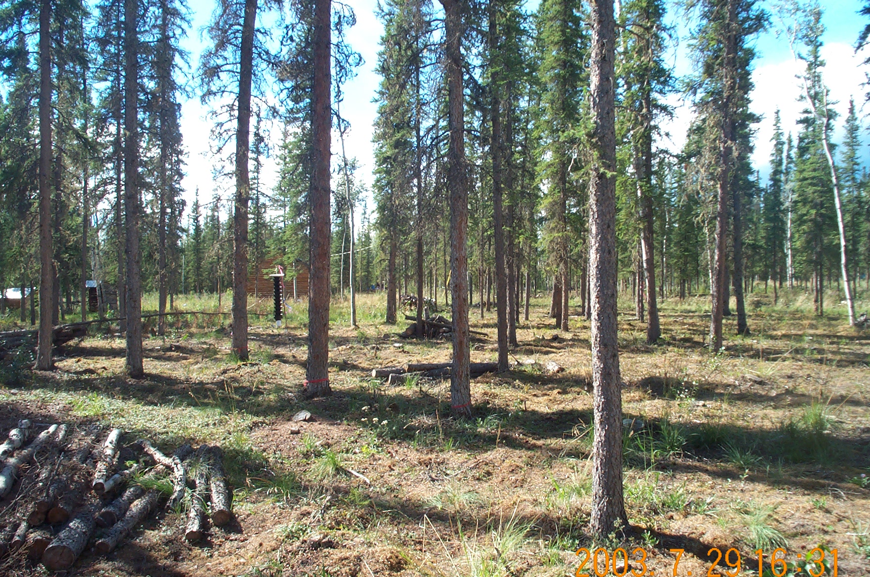
Fuelbreak around Tanacross, Alaska
Molina A, Little J, Drury S, Jandt R. Homeowner Preferences for Wildfire Risk Mitigation in the Alaskan Wildland Urban Interface. Sustainability. 2021; 13(21):11754. https://doi.org/10.3390/su132111754
Forestry research in Alaska indicates that coniferous-dominated interior boreal forests are being replaced by deciduous trees due to recent climate warming and changes in the wildfire regime. Mann et al. 20121 suggested a dramatic shift in forest species dominance was already happening, since the 1990’s. Interior Alaska forests have averaged about ⅔ coniferous to ⅓ deciduous over the last several hundred years. Using landscape disturbance models under various global climate scenarios, Mann’s team predicted the ratio would soon be 1:1 and even reverse by mid-century, with hardwood stands comprising ⅔ of the forests. Now, 30 years of satellite imagery and improved vegetation mapping methods using new technology offer a chance to test their predictions.
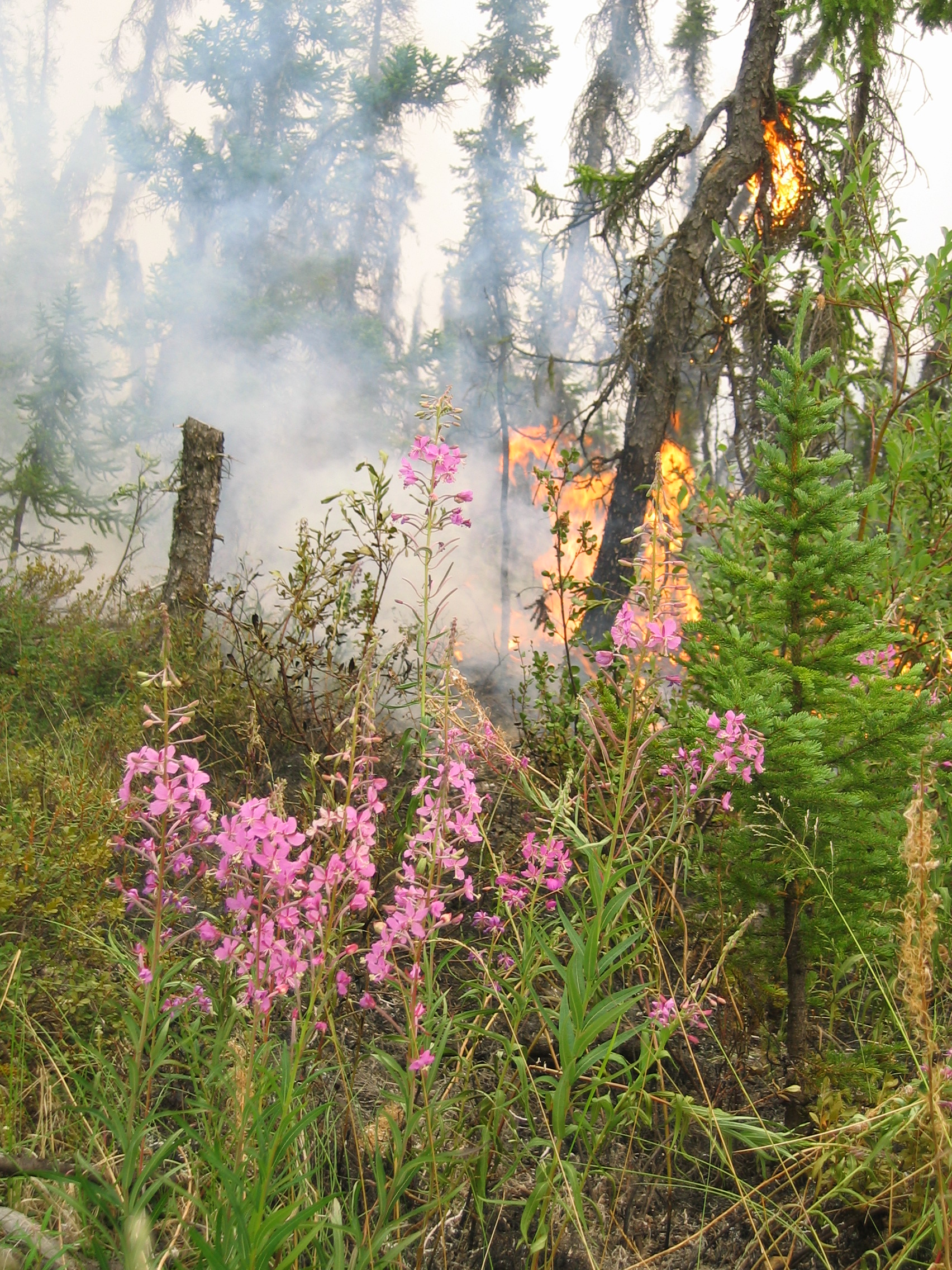
Post-fire succession: When Alaska spruce forests burn the trees are killed, but black spruce stands tend to “self-replace” about ⅔ of the time—by seeding into the remnant moss layers2. On the other hand, it has been well-documented that “severe” (deep-burning) forest fires favor regrowth of hardwoods (birch, aspen and poplar). These species can grow fast in deeper active layers that result after severe fires in which most of the moss duff is removed3. This can result in a “relay succession” recovery where hardwoods dominate the canopy for a time before slower growing spruce can regain dominance of the canopy. In either case, if the stand reburns within about 50 years, small black spruce in the understory are destroyed before developing a robust seed bank, and the stands tend to become increasingly hardwood dominated. Ongoing studies to refine these parameters in eastern interior Alaska reveal that pure black spruce stands transitioned to deciduous forest about half the time after a severe fire4. Coniferous forest with even a small percentage of deciduous stems (> 7%) succeeded into a mixed-wood composition (50:50) and stands which had >30% pre-fire deciduous stems became exclusively deciduous.
Why is a shift in forest species important? Spruce forests have vastly different properties than broadleaf forests. These differences include: higher flammability, lower water uptake, slower litter decomposition rates, different atmospheric heating properties (surface albedo), and carbon sequestration capacity. Of course, they also differ with respect to supplying wood, game, and berries to humans. Black spruce trees thrive in cold, moist soil conditions, and actually enhance these conditions by accumulating a deep mossy soil organic layer. The moss layer is often too moist–with snowmelt water, rainfall, and seasonally thawing ice below–to support combustion beyond a few centimeters deep. Most of the carbon (C) stored in these slow-growing forests is in the moss and soil organic layers. Warmer summers and extended burning seasons in late summer tend to allow the moss duff layers to dry faster and deeper. In western Canada, 90% of C combusted in extensive 2014 fires in black spruce forest came from the forest floor 5. Deciduous trees, on the other hand, thrive in nutrient rich, dry and (relatively) warm soils, and reinforce these conditions with high decomposition rates, so the soil organic layer tends to be shallow. Their faster growth rate (productivity 5-7 times greater than black spruce forest) means that they store most of their C aboveground in the trees themselves6. Deciduous trees also require more water to sustain that rapid growth—a lot more! It was recently discovered that Alaska broadleaf trees take up 25% of available spring snowmelt water (compared to about 1% for spruce)7. But mature spruce forests (aged 70-120 years) win out when it comes to long-term C storage — they had 4-10 times the C stored in their organic soils (2.0-5.7 kg C m-2) compared to 50-year-old stands8.
Was the forest shift prediction accurate? Back to the changing forest composition. What does the latest research tell us about the predictions of a decade ago? As part of a multi-year NASA study, Wang, et al. 20209 used an enormous data set of satellite-derived vegetation cover type estimates covering all Alaska and northwestern Canada from 1984 to 20149. They documented a net loss of 14.7% (+/- 3%) coniferous forest along with an equivalent net gain of deciduous forest. These results seem consistent with the predicted forest composition shift caused by a more active fire regime in boreal forests relative to the last several millennia. In an ongoing separate study, preliminary data showed that in burned areas of the boreal biome the ratio of deciduous to evergreen forest cover increased 14.4% (from 23.4% to 37.8%) from 2001-2016, which was 3.3 times higher than in unburned areas10. However, these same authors also documented that mixed and deciduous forest types may be burning more now compared to previous decades, perhaps even burning at a faster rate than they were being replaced during the study time window. In addition, by coupling two types of remotely sensed data for vegetation, the researchers could estimate forest biomass and tree-canopy structure. This analysis showed that recovering burned forest, whether it succeeded to deciduous forest or remained evergreen, still had overall lower biomass and canopy density compared to areas that did not burn. This finding has implications for management scenarios involving fire use to reduce future fuel loadings, and also for carbon sequestration studies. Separate investigations confirm the loss of forest biomass across eastern interior Alaska and predict this will become the modern trend as the climate warms4. Impacts on wildfire and permafrost dynamics will result in overall decreases in biomass (particularly for spruce within the interior Tanana Valley, despite increases in quaking aspen biomass) and result in a continued shift towards a higher deciduous fraction. To a lesser extent, increased biomass is seen at certain locations, such as cold or wet locations, and at high elevations, such as along the north slopes of the Alaska range11. In summary, recent studies seem to support the predictions made a decade ago1 with respect to spruce forest declining and broadleaf and mixed forest increasing across interior Alaska.
What about negative feedbacks to boreal burning? Deciduous forests are more resistant to fires than spruce forests—a guiding principle of much fire suppression and fuel treatments strategy12. Under average summer conditions, coniferous forest is more conducive to large fire spread and accounts for at least half of the average yearly burned extent. Since hardwood forests are less flammable, why doesn’t a negative feedback kick in to reduce flammability as deciduous forests become more common on the landscape? The short answer is that most mega-fires burn in unusually hot/dry summers, and once the fire weather gets extreme enough, deciduous forests and regenerating forests become equally receptive to burning13. The “unusual” heat is becoming more “usual” in recent decades, and future climate scenarios predict dramatic increases in high fire danger days. As for the future of forests in Alaska, new models at the stand level are being developed which include the latest understanding of forest environmental drivers and physiological constraints4,11. A research study funded by the Department of Defense in eastern interior will be sharing findings regarding fire-prone areas of Alaska from Fairbanks to the Canadian border, complete with web visualization tools for managers (beta version: https://masseyr44.users.earthengine.app/view/decidfractreecoverserdpv1).
The takeaway: Alaska’s boreal forest is undergoing major changes driven by the domino effects of changing climate. Boreal forests are experiencing changes in the fire regime, which through interactions with the ecological and physiological attributes of trees are causing widespread shifts in forest composition. Those shifts in turn are causing a shift towards net C release to the atmosphere which could accelerate global warming. Overall, these shifts in forest species dominance are a fascinating example of how even a relatively simple biome like boreal forest can have complex responses to changes in climate.
Acknowledgements: Many thanks to Dr. Dan Mann and Dr. Eric Deutsch for helpful discussion and interpretation and to Zav Grabinski for editing help.
References: 1 Mann, D. H., T. S. Rupp, M. A. Olson, and P. A. Duffy. 2012. Is Alaska’s boreal forest now crossing a major ecological threshold? Arctic Antarctic and Alpine Research, v. 44, no. 3, p. 319-331.
2 Baltzer, Jennifer et al. 2019. Widespread ecological reorganization of boreal forests following severe wildfires. AGU Poster B33B-07, San Francisco, CA Dec. 9-12, 2019.
3 Hollingsworth, T. N., J. F. Johnstone, E.L. Bernhardt, S. F. Chapin. 2013. Fire severity filters regeneration traits to shape community assembly in Alaska’s boreal forest. Plos One 8(2):e56033.
4 Goetz, Scott, et al. (ongoing) SERDP Project RC18-C2-1183: Resiliency and Vulnerability of Boreal Forest Habitat across DoD Lands of Interior Alaska.
5 Walker, X. et al. 2018. Cross-scale controls on carbon emissions from boreal forest megafires. Global Change Biology 24 (9): 4251-4265.
6 Alexander, H. and M. Mack. 2016. A Canopy Shift in Interior Alaskan Boreal Forests: Consequences for Above and Belowground Carbon and Nitrogen Pools during Post-fire Succession. Ecosystems 19: 98-114.
7 Young-Robertson, J. M., W.R. Bolton, U.S. Bhatt, J. Cristóbal, R. Thoman. 2016. Deciduous trees are a large and overlooked sink for snowmelt water in the boreal forest. Scientific Reports 6:29504.
8 Hoy, E.E., M.R. Turetsky and E.S. Kasischke. 2016. More frequent burning increases vulnerability of Alaskan boreal black spruce forests. Environ. Res. Lett.11 095001
9 Wang, J. A., D. Sulla-Menashe, C.E. Woodcock, O. Sonnentag, R.F. Keeling and M.A. Friedl. 2020. Extensive Land Cover Change Across Arctic-Boreal Northwestern North America from Disturbance and Climate Forcing. Global Change Biology 26, 807–822.
10 Deutsch, E.J. and M.L. Chipman. 2020. Observations of Post-Wildfire Land Cover Trends in Boreal Alaska Using Geospatial Analyses. AGU Poster, Virtual, Dec. 1-17, 2020.
11 Foster, A.C. et al. 2019. Importance of tree- and species-level interactions with wildfire, climate, and soils in interior Alaska: Implications for forest change under a warming climate. Ecol. Modeling 409: 108765.
12 Beverly, J. L. 2017. Time since prior wildfire affects subsequent fire containment in black spruce. International Journal of Wildland Fire 26:919–929.
13 Barrett, K, T. Loboda, A.D. McGuire, H. Genet, E. Hoy, and E. Kasischke. 2016. Static and dynamic controls on fire activity at moderate spatial and temporal scales in the Alaskan boreal forest. Ecosphere7(11): e01572. 10.1002/ecs2.1572.
14 Dash, C.B., J.M. Fraterrigo, and F.S. Hu. 2016. Land cover influences boreal forest fire responses to climate change: geospatial analysis of historical records from Alaska. Landscape Ecology 31:1781–1793.
A pair of new 2021 papers take different tracks to assess the impact of human activities and anthropogenic climate warming, on fire season in south central Alaska. We still remember how smoke choked the Kenai and Matsu boroughs in 2019, for most of June-August. A University of Alaska team tallies the impacts–in $$, losses, and human health, while also placing the season in a historical context to look for anthropogenic influence. They deemed human influences thus far were less important than weather, but would become more of a factor by mid-century. An important finding was that heating seemed to overpower increased precipitation (over longer timescales): “The effect of warming temperatures dominates the effect of enhanced precipitation in the trend towards increased fire risk.” Read the full paper HERE: Uma S. Bhatt, et al. 2021. Emerging Anthropogenic Influences on the Southcentral Alaska Temperature and Precipitation Extremes and Related Fires in 2019. Land. 2021; 10(1):82. https://doi.org/10.3390/land10010082
A second team, led by Princeton scientist Yan Yu, did a different type of analysis and tried to incorporate other factors such as anthropogenic ignitions, population density, and increased conifer biofuels. Although the increased fuels may be largely an assumption in their paper, at least for the Kenai region it is validated by Carson Baughmann’s (USGS) 2020 study: Four decades of land-cover change on the Kenai Peninsula, Alaska: detecting disturbance-influenced vegetation shifts using Landsat Legacy data. Yu’s team asserts there is evidence that part of the increase in fire risk is human-caused: “The . . . model indicates a threefold increased risk of Alaska’s [southcentral region] extreme fires during recent decades due to primarily anthropogenic ignition and secondarily climate-induced biofuel abundance.” Read their paper HERE: Yan Yu, et al. 2021. Increased Risk of the 2019 Alaskan July Fires due to Anthropogenic Activity, Bulletin of the American Meteorological Society 102(1): s1-s7. https://journals.ametsoc.org/view/journals/bams/102/1/BAMS-D-20-0154.1.xml
At their “All Hands” meeting in November a diverse array of researchers presented quick overviews of their findings the University of Alaska National Science Foundation-sponsored research project called EpsCor Fire & Ice. The scope of projects—many guided by the participation of fire managers and other stakeholder groups in Alaska—was remarkable. Below are a few sample highlights that will convince you to check out their slide deck summary from the meeting [HERE].
Alaska’s first ever study of wildfire smoke-related health outcomes (respiratory and cardiovascular) by Micah Hahn at UAA. She used a database on emergency room visits in Anchorage, Fairbanks, and Matsu (which collectively could account for 60% of Alaska’s population) during wildfire seasons 2015-2019. The biggest correlative effect with smoke seemed to be asthma: In Anchorage, for example, a 13% increase in ER visits was noted on days of elevated wildfire smoke (PM 2.5) exposure. A paper with full results is expected to be out soon.
Remote sensing specialists in the Boreal Fires team (Smith, Bandola, Panda, Waigl) continue to make headway with using newly available multi-spetral remotely sensed imagery and high-tech computational processes to improve Alaska fire fuels maps (Figure, below). Managers and fire modelers have repeatedly stressed that inaccurate mapping of fuels is one of the biggest limitations currently impeding better fire spread modeling.
Remote sensing products can also improve the quality of burn severity maps, even in WUI areas where suppression is still active (Schmidt).
Homeowner surveys in fire-impacted areas revealed how much risk homeowners thought they had prior to the fires and how they were directly impacted (Schmidt).
Why do some fire scars have great morel mushroom crops and others don’t? That vexing question was tackled (Yamin-Pasternak) with input from lots of participating harvesters who also pronounced the fire season of 2020 as the longest ever! Hint: they also ranked recent fires around the state relative to their productivity—a result you’re going to want to examine.
Erik Schoen and Ben Meyer from the UAF Institute of Arctic Biology studied the effects of the 2019 Shovel Creek fire on juvenile salmon. Although differences were found in water quality and food availability in burned vs. unburned reference areas, the growth rates of the fish were similar.
Comparing accuracy of LANDFIRE and AVIRIS fuels mapping (C. Smith, AHM Nov. 4, 2020).
Those highlights ought to convince you to spend a few minutes looking at the slide deck from the meeting, just to see more items from this amazing interdisciplinary collaboration of science and management! Likely there’s a researcher looking for collaboration and input from you in your fire specialty, and Alaska Fire Science Consortium can help you make a connection. Go to https://www.alaska.edu/epscor/publications-presentations-posters/ and look for the 2020 Alaska EPSCoR All Hands Meeting, Boreal Fires component.
Can remote sensing products help mitigate the loss of on-the-ground resources due to the COVID-19 pandemic?
Chris Waigl and the EPSCoR Boreal Fires Science team are rapidly developing new tools to aid with the fire season in Alaska. Products include, enhanced access to daily snow cover extent and fire danger maps, and highly focused fire-detection algorithms. The tools aim to provide data that can be integrated into existing systems facilitating direct applications for users, including fire operation managers.
Remote sensing of daily snow cover extent
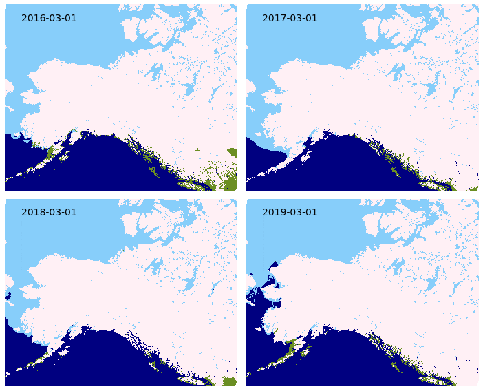
Spring 2020 saw the introduction of a new daily snow cover extent mapping product for the state of Alaska. The source data from the NOAA National Ice Center is based on near-real time readings from the Interactive Multi-sensor Snow and Ice Mapping System (IMS). This satellite multi-sensor can differentiate between snow, ice, water, and snow-free ground with high levels of accuracy. The snow cover product is available seasonally for download as a vector file and as web-browser map with near-real time updates through the Alaska Interagency Coordination Center (AICC) mapping service, and year-round (with limited updates) from the Boreal Fires Team. Inter-annual comparisons of snow cover (Figure 1) can be made by geographic zone or throughout the state. This snow classification data could potentially be improved by validation through Moderate Resolution Imaging Spectroradiometer (MODIS) and Visible Infared Imaging Radiometer Suite (VIIRS) products, National Weather Service snow depth data, and citizen science projects that measure snow depth.
Figure 1. Inter-annual comparison of snow melt across Alaska and northwest Canada, 2016-2019. Green regions represent snow free areas. This animated comparison is just one way the data snow cover data can be visualized. The snow cover data can be obtained as a vector file, allowing for fine-scale pattern analysis within smaller geographic extents.
Improving access to spatial representations of Alaska Fire Danger Ratings
The Canadian Forest Fire Danger Rating System (CFFDRS) combines fire occurrence prediction systems, fire weather indices, and fire behavior systems to establish a fire danger rating. MesoWest produces fire danger ratings from CFFDRS for Alaska. The Boreal Fires team helps make this data more accessible by processing the MesoWest GeoTIFFs into a format that can be more easily used for webmapping by AICC. These fire danger ratings are available on the AICC web-mapping service and also hosted by the Boreal Fires Team. The fire danger ratings, known as Spruce Adjective Ratings, are grouped into low, moderate, high, very high, and extreme classes. These discrete groupings along with provincially specific parameters can create harsh differences in adjacent areas at province and international borders. CFFDRS has proven to have great application to Alaska. The Boreal Fires Team hopes that making the danger ratings more accessible will open the door for fine tuning the data to seamlessly fit Alaska, and lead to improved integration into fire behavior and analysis tools for the state.
Figure 2. Processing CFFDRS source data for Alaska creates an accessible spatial representation of Spruce Adjective Fire Danger Ratings. Fine tuning the application of the indices to Alaska could improve the interoperability of CFFDRS in Alaska.
VIFDAHL (VIIRS I-band Fire Detection Algorithm for High Latitudes)
VIIRS fire detection has shown to be invaluable for remote fire detection at high latitudes. VIFDAHL compliments VIIRS by subsetting high fire-danger areas and known fire locations. This information is particularly important for fire operations managers. Low-intensity detections have direct application to spotting residual fire hazards, which can help with resource prioritization Having additional inputs for where fire is now, particularly low-intensity detections, is helpful to identify ignition sources for fire behavior models.
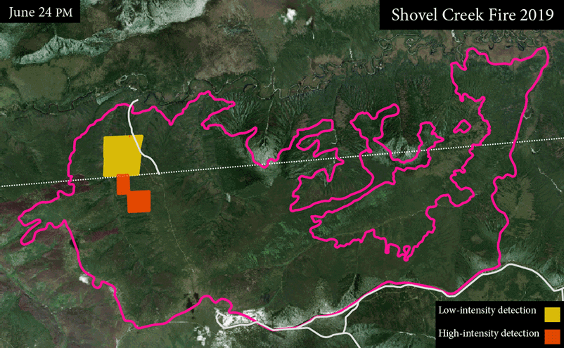
Figure 3. VIFDAHL can provide up to two fire detections per day from satellite fly overs providing valuable near-real time information. In this animation fire detections are shown for the 2019 Shovel Creek Fire near Fairbanks. Some satellite flyovers produce no usable information due to atmospheric interference such as clouds.
Now halfway through it’s 9-year funding life, the NASA Arctic Boreal Variability Experiment (ABoVE) is connecting some high-level science findings with practical applications for a variety of stakeholders. The 6th ABoVE Science Team meeting held virtually June 1-4 highlighted a number of these and happily, recorded them for you as well. The interactive posters are well done and a quick read–look for a subject of interest to select a group of interest (e.g. “Fire” returned 9 posters). Not surprisingly, much ABoVE research is focused on big-picture questions like– Can we see trends in vegetation composition, disturbance (like fire and insects), release of greenhouse gases into the atmosphere, and regional weather conditions across the North American boreal region? Specifically, ABoVE is harnessing 30+ years of earth satellite observations, big data management, and brand new remote sensing platforms to answer these questions.
Notably, in this year’s meeting we are seeing the APPLICATION of the science directly with stakeholder groups in Alaska and Canada on very specific management questions. For example:
Helping Alaska wildlife biologists determine if snow conditions are suitable for conducting the winter moose counts without wasting lots of airplane hours and fuel (Boelman)
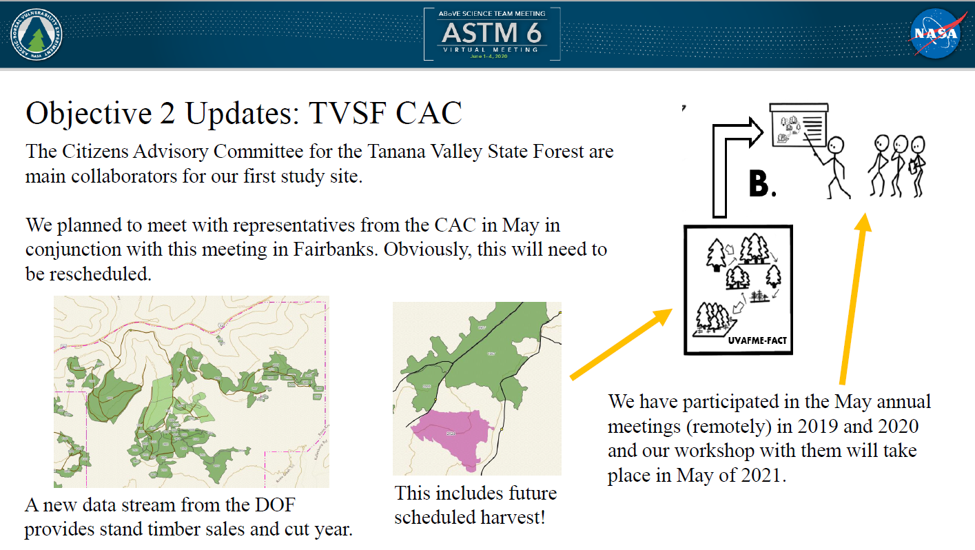
Assisting management of the Tanana Valley State Forest by providing detailed stocking and biomass information from remote sensing and modeling the effect of management (harvest) into the future for planning (Lutz)
This project is using remotely sensed forest biomass and canopy height to help harvest plans for forest lands around Fairbanks is a great example of practical applications. (slide: David Lutz)
Correlating human health outcomes in Alaska with remotely-sensed smoke conditions (Loboda)
Mapping wetlands and determining waterfowl habitat suitability and future climate impacts with Ducks Unlimited (French).
Fire managers have long coveted a remote sensing method to track moisture content in deep organic soils to indicate drought level and potential for large wildfires and deep combustion and there has been terrific progress on this subject (Schaefer, Tabatabaeenejad).
Widlife managers have desired a way to map and inventory lichen cover on caribou ranges: Matt Macander’s ABoVE team has come up lichen cover maps that validate very well with aerial surveys (Epstein–slide 1).
Connect with us for more information on these projects, or others YOU may want to be involved in or use information from, and browse the Agenda to learn more about what else ABoVE is up to!
Arctic Urban Risks and Adaptations: a co-production framework for addressing multiple changing environmental hazards
Jen Schmidt – University of Alaska Anchorage
Arctic Urban Risks and Adaptations (AURA) is a new, four-year NSF project addressing changing environmental hazards around Anchorage, Fairbanks, and Whitehorse. Understanding how wildfire hazards are changing, and the associated risks and costs are a primary focus of the study. Overlapping risks associated with wildfire, including permafrost thaw and rain-in-winter, are being integrated as a unified approach to assessing environmental hazards. The co-production framework of the project strives to use land manager and community input to produce decadal wildfire hazard mapping and assessment tools by leveraging existing datasets other resources.
Currently fuels treatment datasets are spread across multiple agencies and are often lacking important information such as year of treatment. As part of a new four-year project, Jen Schmidt (PI) and the EPSCoR Boreal Fires Team hope to collaborate with others to provide comprehensive-online GIS layers that land managers and others could use to efficiently find where fuel treatments may exist. Having a centralized fuel treatment database with aerial imagery and management zones (Figure 1) would allow agencies to quickly check for prior fuel treatments, providing a valuable tool to aid in decision making and planning.
Assessing wildfire hazards over time
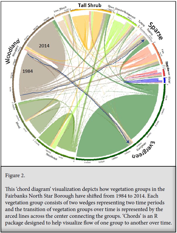
As part of the hazard analysis, Jen is employing recently completed NASA ABoVE (Arctic – Boreal Vulnerability Experiment) 2014 vegetation maps. These maps categorize 1984-2014 LandSat imagery of arctic and boreal forests in 15 vegetation types. The dataset has great application for visualizing vegetation change over time. In this chord diagram (Figure 2), you can follow transitions of vegetation groups in the Fairbanks North Star Borough by looking at the lines in the center of the chart connecting the groups from 1984-2014. For example, note the many transformations of “woodland” (tan) to multiple vegetation types, including “evergreen” (green) and “sparse” (gray) forests over the 30-year time period. Fire is a key driver of these vegetation changes and being able to track the transition of vegetation types can improve understanding of how vegetation composition changes in response to fire, which can aid in modeling wildfire hazards.
Wang, J.A., D. Sulla-Menashe, C.E. Woodcock, O. Sonnentag, R.F. Keeling, and M.A. Friedl. 2019. ABoVE: Landsat-derived Annual Dominant Land Cover Across ABoVE Core Domain, 1984-2014. ORNL DAAC, Oak Ridge, Tennessee, USA. https://doi.org/10.3334/ORNLDAAC/1691
Spatiotemporal patterns of overwintering fire in Alaska
Rebecca Scholten and Sander Veraverbeke – Vrije Universiteit Amsterdam
What are holdover and overwintering fires?
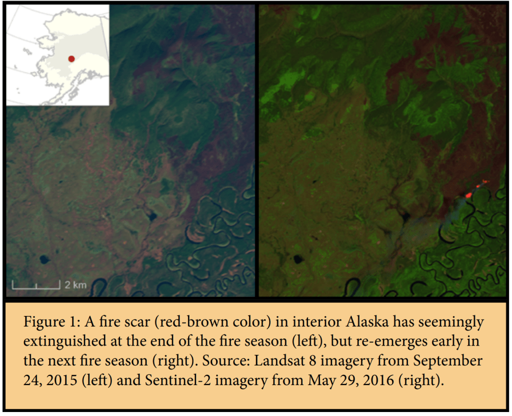
Fires can appear to be out, but retain smoldering combustion deep in the fuelbed and flare up again when the weather favors flaming behavior and fire spread. This phenomenon occurs not unfrequently in boreal forests of North America, and presents a well-known challenge to firefighters. Over the last two decades, fire managers noted increasing occurrences where fires survive the cold and wet boreal winter months by smoldering, and re-emerged in the subsequent spring.
Scientists and managers seek better understanding of how these fires sustain during such unfavorable conditions. Fire managers have already started targeting locations where they expect fires to flare up again. However, they are missing detailed information on the environmental and climatic factors that facilitate these fires. This information is crucial to detect fires at an early stage and keep firefighting costs low. A research group at Vrije Universiteit Amsterdam is studying when and where these holdover fires emerge and how their occurrence is tied to specific geographic locations.
Mapping overwintering fires from satellite data
Since 2005, fire managers reported data on 39 holdover fires that survived winter in Alaska. However, the location and emergence date of these fires were used in conjunction with satellite data to develop an algorithm for overwintering holdover detection. From satellite imagery, we can only observe fires that are large enough to generate a considerable amount of heat and burn a large enough area. Consequently, 32 out of 39 reported overwintering fires were too small (all smaller than 11 ha, 25 out of 32 smaller than 1 ha) to be detected from space. The location and emergence date of these small overwintering fires were used for the calibration of an algorithm focused on large overwintering fires. From the remaining seven large reported overwintering fires, our algorithm classified 6 out of 7 as overwintering fire. In addition, our approach revealed 9 large overwintering fires that were not reported by agencies between 2002 and 2018 in Alaska. A results paper is currently in preparation.
The spread rate of smoldering fires is known to be very low, and a smoldering fire would spread only between 100 and 250 m in an entire year (Rein, 2013). So, overwintered fires usually emerge within or close to the previous year fire (Fig.1) and can re-emerge with flaming behaviour as soon as favourable burning conditions appear in spring develop in to flaming forest fires before the major lightning-induced fire season. The onset of warm and dry conditions varies from year to year depending on the winter and spring temperatures and precipitation. These variables also shape the regional snowmelt day, which can be inferred from satellite observations. Indeed, our research indicates that holdover fires usually re-emerge within 50 days after the regional snowmelt. Overwintering fires are more likely to occur the year after a large fire
year (Fig. 2).
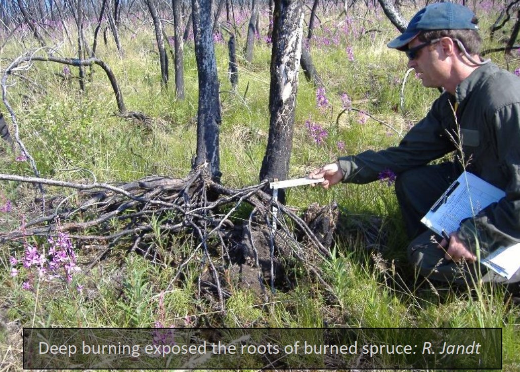
Can we predict where overwintering may re-emerge?
It is not only important to know when these fires emerge, but also where. We therefore analyzed spatial drivers of the overwintering fires we detected. Our research indicates that holdover fires are facilitated in those regions of a fire perimeter that had burned deeper into the organic soil the year before. Deep burning is a characteristic of a high severity fire. We also observed that overwintering fires were more likely to emerge in lowland areas with black spruce-dominated forest. Overwintering fires thus have some temporal and spatial predictability. Monitoring the edges of fire perimeters from the preceding year in lowland forested peatlands early in the fire season, and especially after a year with large burned area, may prove beneficial to extinguish flare-ups from overwintering fires before they develop into a large flaming forest fire. This could be a cost-efficient strategy for fire management agencies. In addition, this would preserve terrestrial carbon by safeguarding it from combustion.
Figure 2: Years with a large burned area (grey bars) are more likely to generate
overwintering flare-ups (orange bars) than years with less burned area
References:
Rein, G. (2013). Smouldering Fires and Natural Fuels. In C. M. Belcher (Ed.), Fire Phenomena and the Earth System: An Interdisciplinary Guide to Fire Science (pp. 15–34). https://doi.org/10.1002/9781118529539
Turetsky, M. R., Benscoter, B., Page, S., Rein, G., Van Der Werf, G. R., & Watts, A. (2015). Global vulnerability of peatlands to fire and carbon loss. Nature Geoscience, 8(1), 11–14. https://doi.org/10.1038/ngeo2325
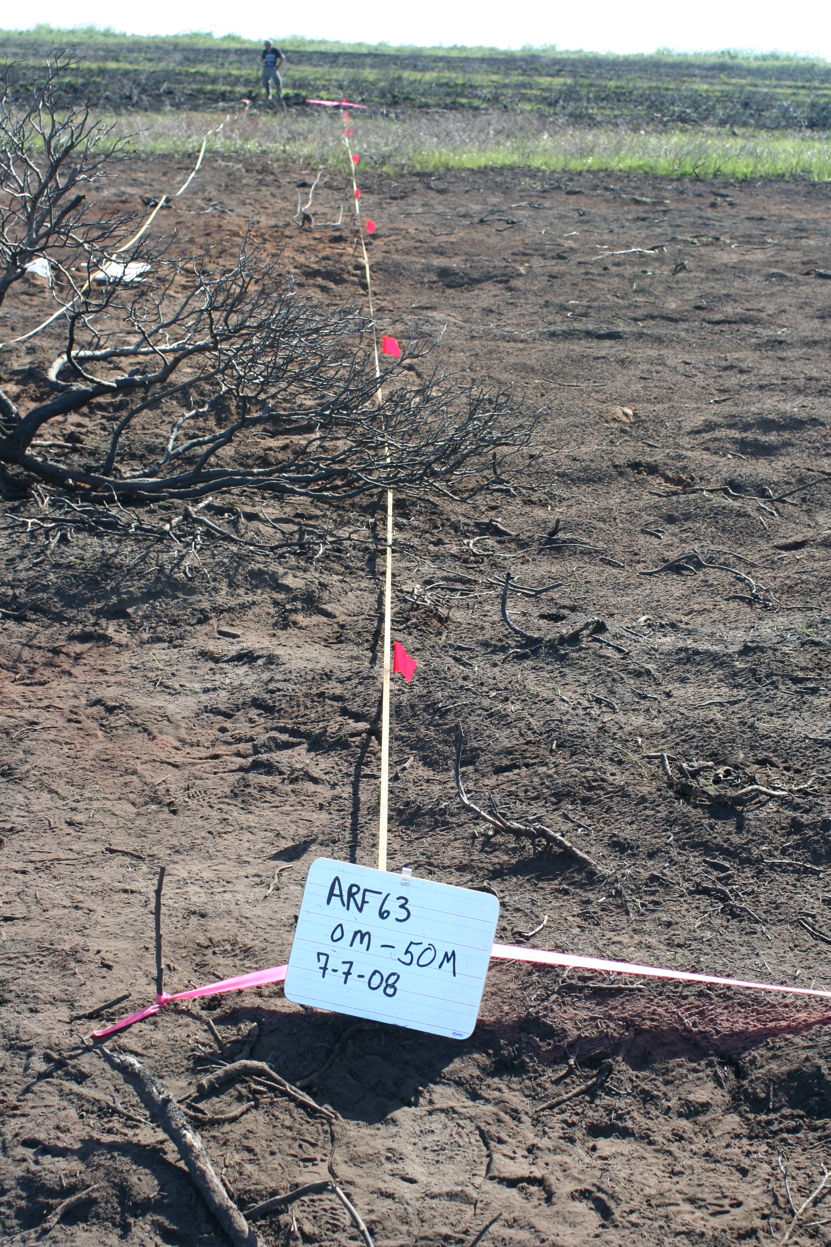
As discussed in the Feb. 7 Fire Science Highlight, burn severity in Alaska is best related to the amount of consumption of the forest floor—not the degree of tree canopy mortality as is in temperate pine and fir forest. Yet the most commonly applied metric to map burn severity using satellite remote sensing does not correlate well with substrate burn severity. The change in Normalized Burn Ratio (dNBR; Key and Benson 2003) is based on comparing a pre- and a post-fire image. However, NBR thresholds for severity differ from one fire to another and among different years: similar numbers don’t indicate the same severity levels (D. Chen et al. 2020). And with tundra fires, sometimes it works, other times not. This problem has dogged fire effects and ecology studies in Alaska for some time (see list of papers in Sean Parks November 2019 presentation) leading French et al. (2008) to conclude: “Satellite remote sensing of post-fire effects alone without proper field calibration should be avoided.”
2008 Transect photo from Anaktuvuk River tundra fire (R. Jandt)
Recently, we’ve seen some promising new methods used to improve satellite remote sensing of burn severity in boreal forest. Whitman et al. compared several indices including a relativized index that facilitated comparisons between different fires in Canada. She told us about it at the Opportunities to Apply Remote Sensing in Boreal/Arctic Wildfire Management and Science Workshop in 2017—here’s her presentation if you missed it: Improving Remotely Sensed Multispectral Estimations of Burn Severity in Western Boreal Forests. Loboda et al. ( 2020) found single images using just NIR (near-infrared) bands of Landsat did better than NBR in discriminating tundra fire severity. Sean Parks is attempting to harness the power of Google Earth Engines and cloud-based computing to use multiple images to further define the ecological burn severity (Parks et al. 2019)—this work is kicking off at the University of Montana. He also found that unusual aspects of some fires in Alaska (pre-existing beetle kill, short fire return interval) contribute to poor performance of the standard index (see his recorded November, 2019, Association of Fire Ecology meeting presentation HERE). And Yaping Chen, from the University of Illinois, explored using indices based on Visible and NIR bands (which have a large archive of available imagery going back to the early 1970’s) to evaluate tundra fire severity. Her paper (Y. Chen et al. 2020) points to a VNIR index called GEMI as a “robust surrogate to NBR in Arctic tundra ecosystems, capable of accurately estimating fire severity across fire seasons, tundra fires, ecoregions, and vegetation types.” The fact that GEMI is not as influenced by different vegetation types as dNBR gives it a distinct advantage mapping tundra burn severity.
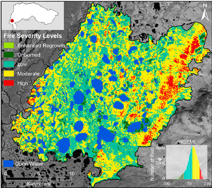
Being able to more accurately map burn severity levels from space would give ecologists a boost for understanding why fires sometimes induce radical changes in ecosystems while other times the system self-replaces in a very short span. For example, Yaping Chen used GEMI to reconstruct burn severity on older tundra fires like the 1977 example below and tie it to thermokarst effects (like catastrophic lake drainage or ponding) resulting from the fires (poster presented at AGU meeting December 2019). We look forward to more exciting products and tools coming from these research teams!
Reconstructed fire severity map of the 1977 OTZNNW 38 tundra fire computed with dGEMI using Landsat MSS imagery.
Key, Carl H.; Benson, NC. 2003. The normalized burn ratio (NBR): A Landsat TM radiometric measure of burn severity. US Geological Survey Northern Rocky Mountain Science Center.
In Alaska, we know that post-fire recovery of spruce forest generally takes one of two major pathways. Fires in spruce forest burn with high intensity and it is typical for 90-100% of the standing trees to be killed in the fire, so trees primarily regenerate by seeds released from the cones—often preserved and dried in the dead snags with the heat of the fire. What happens next is largely dependent on the amount of forest floor moss layers consumed in the blaze: if much is consumed, maybe even leaving patches of mineral soil, we consider this a high severity fire, whereas if only a few centimeters of moss duff have been removed, we consider the fire severity to be low. Black spruce
Photo by USFS, PNW (2004).
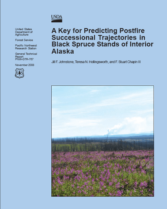
readily re-establishes itself after low-to-moderate severity fires because its abundant and relatively large seeds can germinate and survive a few dry spells in the peat-like substrate of the remaining organic forest floor. This is called “self-replacement”. Other tree species, including white spruce and the deciduous trees prefer a more exposed mineral seed bed, which may offer more consistent moisture and nutrient availability. After higher severity fires, grass and fireweed are notable early on and followed by a period of shrub and deciduous tree seedlings and re-sprouts. The dominance of the forest may then shift to aspen, birch and/or poplar for a period of years. Ultimately, more shade-tolerant but slow-growing spruce will again dominate, but this may take 50-100 years. This pattern of recovery is termed “relay succession”. The moisture available at the site and pre-fire species composition also influence recovery, as illustrated by Johnstone, Hollingsworth and Chapin in the Key for Predicting Postfire Successional Trajectories in Black Spruce that they prepared for managers in 2008 (below).
Now, here’s the punch line: Alaska ecologists have long been asking themselves what percent of the time, over the whole landscape, does self-replacement vs. relay succession occur? For many modeling efforts to date (LANDFIRE, for example) we had only our best guesses. At a scientific meeting in December 2020 (American Geophysical Union) Jennifer Baltzer, a Canadian forest ecologist, related the findings of a large ecological study with over 1,538 burn study plots across Alaska and western Canada (1,140 of the plots were black spruce forest). Her team demonstrated that about 62% of the time burned black spruce forest recovers by self-replacement (73% for all conifer forest types), while approximately 20% of the plots were headed for a relay type succession. Another 20% or so of the plots were showing little forest regeneration (regeneration “failure”)—which seemed to be more likely after repeat burns in a fairly short time period. The exciting thing about this research is that it provides—for the first time–quantitative estimates for these competing post-fire pathways. The research is being reviewed for publication now–we’ll let you know!